Showing posts with label Then and Now. Show all posts

Friday, August 30, 2013

Then and Now – Anamalai Avenue

Here are two photos of Anamalai Avenue. The top photo is from the PictureSG website hosted by the NLB. It is accompanied by the following explanation; “This 1993 photograph shows Bukit Timah Road, towards Anamalai Avenue (southwards).” Actually, I think this explanation is incorrect. The photo actually shows Anamalai Avenue towards Bukit Timah Road. You can refer to the second photo which was taken by me earlier this month.


On the left of this photo is the Royalville Condo. Beyond this is Bt Timah Rd and behind the trees is the Bukit Timah Canal.

As you can see, the old shops are all gone. In its place is a new building which houses a branch of the OCBC Bank. Previously, the bank was located at the other end of Sixth Avenue Centre, nearest to the traffic lights. Do you know what was the name of this bank previously?


It was known as Keppel - Tat Lee Bank. And before that, it was simply Tat Lee Bank.

Friday, April 05, 2013

Then and Now – Cashin Jetty


The photo that I put up in the latest GMY Book Contest is of the Cashin Jetty near Lim Chu Kang end. Actually I do not know much about this place until my friend James Tann pointed it out to me during my recent visit to the Lim Chu Kang Jetty.


Thanks to Peter Kirkman, I am able to share with you a few more photos of this place taken in the 1960s by his father, Ray Kirkman and forwarded to me by my friend Mike Robbins. I suspect, these photos were taken during the time when we were part of Malaysia. I also suspect that at that time, you could travel to Johor from Cashin Jetty. The reason why I say so is because among Ray’s photos from the same batch, there were several that were of Johor Bahru.


Incidentally, if you want to know more about the Cashin Jetty, its history and what it looks like today, please check out my friend Jerome’s very informative article here.

Wednesday, March 27, 2013

Taman Jurong Heritage Trail - Then and Now; Yung An Road


In GYM Book Contest #5 (03 Feb 2013), I posted an old photo of Yung An Rd which was given to me by my friend Stephen Lai. He is able to recall now that he took this photo some time in 1971 from Blk 118. At that time, he and other pioneer members of our church met regularly for Bible Study at the home of our former (3rd) pastor, Rev James Chan. At that time, our church, the Calvary Bible-Presbyterian Church at nearby Tao Ching Road was still under construction.

For comparison, I tried to take a photo from the same spot, but it was difficult because the view was blocked by some trees; and hence I had to make do with one taken from the top floor of Blk 118 and another from Blk 326.


I believe the building under construction in the old photo was the Chase Manhattan Bank. This bank has long ceased to operate in Singapore, and the building is now being operated by some kind of play school. 


Saturday, February 09, 2013

Then and Now – Lim Chu Kang Jetty


The first time I visited Lim Chu Kang Jetty was on 29 November 1969. My friend Simon Chu and I had cycled to this place from my home in Lorong Kinchir, off Lorong Chuan. We started at 8.30 in the morning and arrived at this jetty at around noon time where we rested and had lunch. I took 2 photos of this place.


This bicycle trip was a memorable experience. In fact, it was the first thing I wrote about when I started this blog. I have also included it towards the end of my book Good Morning Yesterday as I rounded up my memories of growing up in Singapore in the 1950s and 1960s. Here is an excerpt from page 182. It summarizes my thoughts about the places that we saw that day, and the Singapore that I dearly miss.

“It was indeed a memorable trip. We were pretty proud of our achievement. Today my friend has migrated to Scotland but we still remember fondly that arduous bicycle trip that we took more than four decades ago. I miss the places we saw that day. The landscape was very very different. I wish our children could enjoy such a bicycle ride and see the rural landscapes that once covered much of Singapore.”

Recently I visited this Lim Chu Kang jetty with my wife and my friends Peter Chan and James Tann. Below are two photos taken that day.


Wednesday, January 09, 2013

GMY Book Contest #3 - Results

Congratulations to Edwin Lim. I believe this is the junction of Serangoon Road and St George’s Road. Take a good look the Then and Now photos below. The building has not changed much after nearly five decades.


Edwin. Please let me have your mailing address and I will send you a copy of Good Morning Yesterday. You can email me, or message me at Facebook, or post your address here. Thanks to everyone for participating. Look out for Contest #4.

Here are 2 old buildings nearby that are still standing amidst the drastic changes all around.

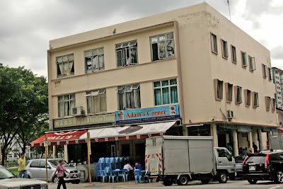
Adam's Corner
Yassin Restaurant

Friday, December 28, 2012

Then, Then, and Now – Stamford Road


I wish I had this photo when I blogged about the old National Library at Stamford Road here. My recollections of this place generated much discussion and speculation about the shops along this stretch of Stamford Rd.


Zooming in on this photo, I can roughly make some of the signboards which have pictures of handbags and crocodiles; and names like Wah Siong Leather, Malaysia …., a vertical Chinese signboard which says; “马来西亚 _Japanese word_ 皮屋” (Malaysia ___ skin house). I would guess that that Japanese word says crocodile or reptile. Another Chinese signboard says, “鳄鱼蛇皮商行 (Crocodile and snake skins trading).

My thanks to Mike Robbins for sending me this mid-1960s photo which was taken by his former colleague, Ray Kirkman. The other two photos were taken by me.


Sunday, November 18, 2012

Then and Now – the former Sussex Estate


In Singapore, old buildings have a way of disappearing overnight. Likewise, new buildings too have a habit of springing up seemingly overnight as these 4 photos of the former Sussex Estate at Clementi illustrate.


For years I have been travelling along Clementi Road and passed by this place called Sussex Estate. I noticed some low-rise buildings there including some kind of veterinary; but had never been curious about them until I visited the Memories of Singapore website hosted by Tom O’Brien and learnt that some British families used to live there in the 1960’s. But sadly, by then, the buildings in Sussex Estate had all been cleared and all that was left was an open field. Hence one day, in 2007, I decided to take a couple of photos of this place from an HDB block in Clementi Avenue 1 to share with Tom O’Brien and his buddies.

Five years have flown by, and that field too has disappeared, and a spanking new estate called Casa Clementi had sprung up. Meantime, across the road, a similar fate had befallen the Warren Golf Club. 

Someone just sent me this old photo of Sussex Estate. Thanks Peter.

Saturday, June 30, 2012

The canal at the end of Lily Avenue


Below are two photos of the canal that separates Lucky Park, where I live, and Eden Park. This canal runs from Bukit Timah Canal to Ulu Pandan Canal, joining it at a point near the junction of Ulu Pandan Road and Clementi Road. It was probably constructed in the 1970s as part of the Bukit Timah Flood Alleviation Scheme. In those days, the Bukit Timah area often experienced floods. In fact, just last year there was a huge flood in this area causing much damage to cars parked in the basement of the Tessarina Condominium.

Taken in 1982, Photo no. 1 is from the National Library Board’s picture archives (Copyright: Lee Kip Lin and National Library Board 2009). On the left is an open piece of land. It used to be a kampong known as Race Course Village. When I moved in to my home in Lily Avenue in 1986, there were still a couple of kampong houses next to this canal. On the right is a factory belonging to Ridsect, the insecticide company. It was still there in 1986. Next to it, facing the main road, was a motorcar showroom. I think I saw Fiat and Mesarati cars on display. Wish I had taken a photo.


 Photo no. 2 was taken recently; and you can see two of the older condos that line much of this stretch of Bukit Timah Road. The one on the left is Royalville and the one on the right is Villa Azura. The narrow strip of land next to the canal is a very nice and quiet place. When my kids were young, I used to bring them here in the evenings. There are many longkang fishes in this canal; and once my children caught some tilapias and brought them home and added them to our koi pond.

My children feeding fish in our koi pond.  c 2002.

This stretch of this canal is next to Maple Lane looking towards Bukit Timah Road.

The canal disappears under some bungalows at Garlick Avenue.

It emerges near the Fong Yun Thai Columbarium at Holland Link. The canal on the right leads to Laurel Wood Avenue and Jalan Haji Alias.

This final photo shows the canal flowing towards the Sungei Ulu Pandan and the former KTM Railway Track.

Like most parts of Singapore, so much of this place has changed. And with the construction of the Downtown Line in full swing; much changes are taking place before our eyes.


Friday, January 27, 2012

Then and Now - Selegie Arts Centre

In my previous post I shared with you Tim Light’s 1960’s photo of Selegie Road. One of the old buildings in that photo has been preserved and is now called the Selegie Arts Centre. According to my brother-in-law who lived grew up in a house Prinsep Street facing this building, there was a corner coffee shop called the London Coffeeshop which used to sell the popular Indian rojak and fresh cow/goat milk. There was a taxi stand next to it and further down Prinsep Street was a government clinic and the ROV (Registrar of Vehicles). In the morning many people would have their breakfast at this ‘London’ coffeeshop.


Photo number 1 – Dated around 1948, Selegie Road and Prinsep Street viewed from the top of Singapore’s tallest building then, the Cathay Building (link)

Photo Number 2 – Dated in the mid 1960’s, it shows the junction of Selegie Road and Prinsep Street. The pick-up truck is making a left turn into Prinsep Street.

Photo Number 3 – Present-day photo where the junction is removed and the tail-end of Prinsep Street is now joined to Selegie Road as one continuous road.


Photo Number 4 – This 1993 photo from the National Archives collection shows the row of shop houses along Selegie Rd being demolished. Only the corner, wedge-shape building is preserved and today it is called the Selegie Arts Centre; recognized by its bright yellow colour.


Photo Numbers 5 & 6 shows the same building in 1993 and 2007.

1981 map of this area

Wednesday, November 30, 2011

Old buildings quiz (17) - Answer

I asked you to identify the old buildings in these photos. The first was taken by Geoffrey Pain’s father sometime in 1965-67 and the second is from the collection of the National Archives of Singapore, which carried this caption; “Housing Board flats for sale in Queenstown – 19/2/1964”.

The correct answer (I think ) should be Blocks 81, 82 & 83, Commonwealth Close. So I went down this afternoon (the place is only 5 km from my home) and took a few photos to confirm. But unfortunately due to the presence of many trees, it was impossible to get a ‘second shot’, which had an unobstructed view of these flats. The best I can manage are these.


And Keith was right. The view from the top of Block 81 was magnificent. The place was deserted. The few old folks that I saw, if they had been living there since 1965, must have witnessed the spectacular changes that had occurred in front of their very eyes over the past four-and-a-half decades.; and still occurring even at this very moment.