Congratulations
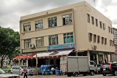
to reader, Chew. The correct answer is Jurong Road. My friend James Tann who
shared this photo from the 1980s said; “This photo of Jurong West as taken
from the Jurong Road roadside at Hong Kah Village. Location should be somewhere
near today's Green Haven Halfway House that was beside the old Bulim Cemetery.”
 |
| The sign which I had blurred out actually says; “Bulim Community Centre" |
But I am still having trouble pinpointing the exact location
because in the 1980s, the PIE had already been constructed; and yet in James’
photo, the HDB blocks looked so near. If this place was indeed near the Green
Haven Home, they should be much further away. Anyway, I hope readers can throw
some light.
Actually, I have blogged about this area before here. In the
old days, when we travelled to Safti via Green Bus 175 or 174 to Nantah, we would pass through this stretch of Jurong Rd. However, we were usually too
tired or sleeping to note the surroundings. As I mentioned in the earlier
article, we also did a lot of topo training in this part of Spore which we
called Hong Kah.
Here are a few more photos of Jurong Rd between Bukit Batok
Road and Green Haven taken in April 2007.
PS – Chew, pls email your address to me so I can send you a
copy of my book.
.JPG)
+copy.jpg)
+copy.jpg)
+copy.jpg)
+copy.jpg)
+copy.jpg)

.JPG)


+0011+STC+13+@+Singapore+late+1950s.JPG)


.JPG)
.JPG)


