Showing posts with label Photos - Joe Elliott. Show all posts

Friday, January 18, 2013

Some old cinemas in town - 1952

Here are some 1951~52 photos of cinemas in the town area courtesy of Joe Elliot. Also cinema tickets from the same period. I have not been to the last 2. A bit too young. Anyone know where was Chung King?


And here’s one more from Mike Robbins taken in the mid-1960s.

Saturday, December 22, 2012

Workmen @ Padang Terbakar, 1952


Here are 4 photos just received from Joe Elliott. They show work being done at Bedok/Padang Terbakar. Joe cannot recall what the workmen were doing at the time. Maybe they are building a bridge using coconut tree trunks. Hope readers can throw some light.
 Here’s a Guide to Singapore book in Singapore 1952. Inside, it had maps of postal districts etc. and a street guide of the city centre itself. Notice there are 3 icons on the cover. The top is unmistakeably the Cathay Building, Singapore's tallest building at that time. Are you able to decipher the other two?


Wednesday, December 05, 2012

Koh Sek Lim Road, 1952


Here is the latest batch of photos received from Joe Elliott. They show the Koh Sek Lim Road which ran from Upper Changi Road to the beach at Bedok. To help you to orientate yourself, I made a scan from my 1963 street directory.

Explanatory notes by Joe Elliott
Photo (1) shows Upper Changi Road from left to right. In front is the Koh Sek Lim Road leading to Bedok Beach and Padang Terbakar. The sign at the start of the road is a Wimpey Sign for the Bedok Sand pit. (The Chinese sign says “公立中莱公学” read from right to left – not very sure about the 4th word)
Koh Sek Lim Road today
Photo (2) – Walking up the road towards the beach.
 
Photo (3) - Coconut trees on both sides of Koh Sek Lim Road leading to Bedok Beach. 

Photo (4) – When you get to the beach, you see this Pill box from the war on Bedok Beach.

 Photo (5) - Bedok Beach at Padang Terbakar showing the Pill box in the distance.

Photo (6) - The beach at Padang Terbakar with the Pill box behind us. To the right of this photo a few yards over the bank, are the Attap Houses of Padang Terbakar. These are shown on photos 7 to 10.


If you look at the map you sent me of the Koh Sek Lim Road - the top of the road shows a right turn - the Houses were on the dotted section of the map and behind these houses was the river marked 'Sungei Bedok' 


Photos 7 and 8 are photos of the Attap House Church which was the original Bedok Methodist Church from 1946 to 1952. In 1952 they had the new church being built down Bedok Road. This was finished by the end of the year.  You can see this on the 1963 map. 

I looked on Google for the Bedok Methodist Church, found their website and contacted them.  I then sent these photos to the Pastor Rev. Sng Chong Hui. He was delighted to see them and said they were going to use them for the 66th Anniversary Celebration which was on 21 October 2012 which they did.

I noticed on one of your Blogs there was a Ron Ho who knew this area and talked about Koh Sek Lim Road. I think he might like to see these photographs as a memory of the past. 

Saturday, November 10, 2012

Attap houses @ Somapah Village, 1952

As a follow up to the previous post about the open-air cinema at Somapah Village, here are two more photos of attap houses along Somapah Road. Young readers who have never seen an attap house close-up and are curious about what the attap roof looks like can check out my post here


You can see more photos of attap houses in another part of Singapore in the mid-1960s here; photos courtesy of Geoffrey Pain. 

Finally here’s a photo of what Joe Elliott describes as a “toilet over cesspool”.

Monday, November 05, 2012

Open-air theatre at Somapah Village, 1952


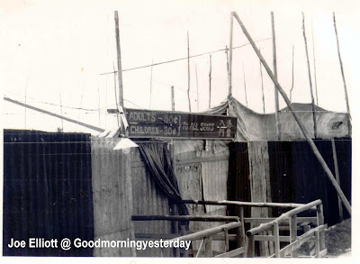
Among the (year) 1952 photos that Joe Elliott sent me, are these gems of an open-air theatre which I believe should be at Somapah Village.

This is the external view of the theatre. The title of the movie, as far as I can make out is “ ” (Little Robin Hood) directed by (  旁) starring and   .  Anyone heard of these names?

This is the entrance “to all seats”; Adult – 50 cts, Children – 30 cts.

Seating and screen area. The Gents is on the left of the screen.

This is the Projection box.

This photo shows the outside of the theatre. To the right of this photo is the open air theatre and in front - left to right - is Changi Rd. The road straight ahead leads to Mata Ikan.


This is Joe’s hand-drawn map of the area. 

After studying the last photo and Joe’s sketch; and comparing it with the 1963 street directory maps of this area (below), I have come to the conclusion that this open-air theatre was located at what was then the Somapah Village; near or at the junction of Jalan Tiga Ratus and Upper Changi Road to be exact. The road leading to Maka Ikan is Somapah Road.


Here is a 2007 map of this area for comparison. Parts of Somapah Road remain.


Below are two recent photos of this area taken from Jalan Tiga Ratus. The first photo is from Google Streetview (probably taken a couple of years ago) and the second photo was taken by me this morning. As you can see, a great deal of construction is going on.


In my book Good Morning Yesterday, I gave a detail description (page 15) of the open-air theatre that I used to go to in the 1950s. This was the South Country Theatre (南国戏院) located at, what is today, the Raffles Institution in Bishan. Thanks to Joe’s photos, more details have come back. For example, the location of the toilets to the right and left of the screen were just like in Joe’s photo. I also recall, now, how we were quite fascinated by the beam of bright light that was projected from the box office over our heads and onto the screen.

As I did not have a photo of the South Country Theatre, I had to search the National Archives’ Picas data base and I managed to find this 1986 photo which I then used in page 132 of my book. According to the description given in the Picas website, this open-air theatre was located at Somapah Village. Could this be the very same theatre in Joe’s photos – albeit an upgraded’ version? Your views please.


Sunday, October 28, 2012

Eating places near Bedok Rest House in 1952 (Updated)


Here are more photos, courtesy of Joe Elliott, of eating places, eating stalls and an itinerant food vendor. Joe recalls in a recent email:

“At the side of Bedok Rest House were stalls on the pavement and behind them on the beach were tables and chairs which you can just see on the photos. The stallholders were cooking various foods which I had at one of tables in 1952.  It was several pieces of meat (not sure what kind) on a thin wooden skewer and a small dish of sauce.  The meat when dipped into the sauce was out of this world - it just melted in your mouth and I've never tasted anything like it since. I knew at the time what they were called but in 60 years I've forgotten. "The memory forgets what they were called but will never forget the taste".

PS – I think Joe must be referring to satay.


Related posts:

Friday, October 12, 2012

Bedok Rest House and Bedok Corner in 1952


Recently I received this email from Joe Elliott of Manchester, England.
“I’ve just found your website – it’s great. I was in Singapore in 1952 with Royal Signals at the Transmitter Station at 9.5 miles stone Changi Road. I went to the Bedok MYF (Methodist Youth Fellowship) at Padang Terbaker* and made many friends there and have many photographs. I could send you some if you're interested.”

To say I am interested would be the understatement of the year don’t you think? And so, here are some photos of the Bedok Rest House and the nearby famous Bedok Corner with more to come. Enjoy!

But first, this is a scan from the 1963 street directory to give you a better idea of the places in these photos.


1) Bedok Corner in 1952 and Oct 2012 (photo courtesy of Peter Chan)


2) Bedok Rest House in 1952 – viewed from entrance and from the beach.


3) Bedok Road near Bedok Police Station in 1952 and Oct 2012 (photo courtesy of Peter Chan)


Finally, here’s Joe and his buddies at the Bedok Rest House.


* According to Peter Chan, Padang Terbakar was a Malay kampong near Hole #1 of Laguna National Golf Club or entrance from Xilin Avenue into Laguna Green beside the Sungei Ketapang bend.


Related post by Peter Chan: Balek Kampong to Bedok Corner