Showing posts with label Ulu Pandan. Show all posts

Friday, September 04, 2009

Gordon Sargent remembers Mowbray Camp

Recently I received a letter all the way from Bulwick, in the UK, from an ex-British serviceman by the name of Gordon Sargent. Gordon took the trouble to write out his letter the old-fashioned way in beautiful cursive handwriting. He shared with me about his time in Mowbray Camp in Ulu Pandan Road from way back in the 50’s. He even included photo copies of two photos.

So thanks to Gordon, you will be able to learn a bit about the history of one of the few remaining British army camps in Singapore. Thanks to contribution from Gordon and other readers, I shall be able to start a new series about old British Army camps in Singapore.

***************************************************

Dear Lam Chun See,


I discovered your photograph from your kampong days when I was doing a little research on Singapore. I spent 19 months at Mowbray Camp a little before your kampong days. I was stationed there from July 1957 to February 1959, so I left Singapore fifty years ago. Amazing where the time goes.

In 1957 the camp was called No. 3 AWDU (Army War Dog Unit). The name was changed some time in 1958 to No. 3 AGDU (Army Guard Dog Unit).
At that time the unit was the base of the Royal Army Veterinary Corps comprising around 150 officers and men with 80 to 100 dogs. Our job was to guard all the army supply bases on the island, including the base ammunition depot which was at Kranji area.

Please find enclosed photo copies of photographs of barrack block.

In 1957 when I arrived at the unit, there were 4 tents in front of the barrack block. We spent the first month in tents. The mosquitoes were hell! The 1957 photo shows 3 tents, so the one I was in had been removed and I had graduated to the barrack building.

I had not been able to establish who in in the camp at present but it is still recognizable on the Google Map.

I hope the enclosed is of interest and would like to hear from you. I am hoping to make a trip to Singapore before I get much older to see several sites I did not see whilst in service.

Yours sincerely,

Gordon Sargent

** Today this Mowbray Camp is known as the Police KINS (Key Installation Protection) Training Camp.

Akan Datang (Coming Soon): Reader Karunakaran shares about his time in the Army Depot Police.

Saturday, January 17, 2009

Can you guess where is this place?

On 20th December 2008, I accompanied some Friends of Yesterday.sg to explore remnants of the old Jurong Line which Peter and I have blogged about in our Ulu Pandan Heritage Trail series last year. I shan’t be blogging about this excursion as my friends PY and Second Shot have already done so.

I just want to share with you one of the interesting photos that I took that day. Do you know where it was taken? To get the answer, please follow PY's articles here.

Sunday, May 25, 2008

Ulu Pandan Heritage Trail (10) – The Lost Railway Line: Part 2 (by Peter Chan)

Photo 1: View from Clementi Block 307 showing the Jurong Line as it crossed the Sungei Ulu Pandan

After the railway crossed the Sungei Ulu Pandan, it swerved to the right (the tracks are still there in front of Clementi blocks 301 and 305) and ran parallel to the river until somewhere behind the Clementi Fire Station and the Buddhist Temple. Then it turned to the left, cut across Commonwealth Avenue West and ran behind ITE Clementi and Faber Terrace until it reached the AYE where it then followed the road westward to Jurong. Next time you travel along the AYE towards the city, look to the left just after the Teban Flyover and you will see some remnants of the railway track. Likewise, if you are traveling along AYE towards Jurong, after you passed Penjuru Road, look to the left and you will also see some remnants of this track.

At Jurong, the Jurong Line terminated at the doors of different industrial activities. Some railway friends of mine spent many hours using old 1960s and recent photos, and the 1985 Street Directory to piece together the many prominent landmarks along the Jurong Line. My appreciation goes to Dominic Thomas and Stanley Tan.

In total there are 3 sub-branch lines ending at.

1) Fishery Port Road
2) Jalan Tepong
3) Shipyard Road


Photo 2: Various parts of the Jurong Industrial Estate were served by the Jurong Line


Photo 3: The “ends” of the Jurong Line

Photo 4a: Jurong Station Signage in recent years


Photo 4b: The same Jurong site some decades earlier. The time-keeper’s hut is visible


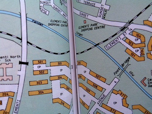
Photo 4c: A 1993 map showing the location of the SBS depot at Jurong Port Road


Industrial users of the Jurong Line included Pan Malaysian Cement Works Ltd, Asia Cement (Malaysia) Ltd, Sugar Industries of Singapore Ltd, and an oil storage company.

The Jurong Line slowed down its freight activities in the mid-1970s but this finally ended in the early 1990s, by which time only the Jurong Port Road section towards Jurong Port was busy. By the mid-90s it was proving difficult to spot its alignment. Not many of the old Jurong Line and its prominent landmark features were visible to the casual observer, unlike the railway bridge across the S. Ulu Pandan or the Teban Garden Tunnel. Railway tracks were either removed because of new construction projects or covered by thick vegetation. Even the wooden railway sleepers rotted over time.

Here’s a question. We know that Malayan Railway Berhad (or its successor KTM) operated the Jurong Line. Who owns the land on which the railway track was built?


Final note from authors:

This concludes our series of articles on the Ulu Pandan Heritage Trail. We hope you have learnt something from them. Perchance some young reader has developed an interest in Singapore’s history, we encourage you to take this up as a school project. Go and investigate some of the places that we have told you about. Take some photos to show to future generations. We fear that before long, even these last vestiges of Singapore’s lost railway line will be sacrificed in the name of progress in fast changing Singapore.

Friday, May 23, 2008

Ulu Pandan Heritage Trail (9) – The Lost Railway Line: Part 1 (by Peter Chan)

In the previous article, Chun See told you about the disused railway line across the Sungei Ulu Pandan. This line was actually part of what was called the Bukit Timah Siding. As the name implies, it was actually an extension of the main Malayan Railway Line which went from Tanjong Pagar to Peninsula Malaya. It was connected to the main railway line near the Bukit Timah Station. After crossing S. Ulu Pandan, it continued all the way to Jurong. Hence it was called the Jurong Line.

According to the 1960 Malayan Railway Berhad Annual Report, the Jurong Line was built by and the project funding came from the company itself and not the Singapore Government. The only reason for the existence of the Jurong Line was purely economics. When Singapore was a part of Malaysia, it was envisaged that Singapore was to be the heavy industrial hub of Malaysia through the Jurong Industrial Estate. At the same time, a small number of Malaysian companies producing essential commodities like sugar were to be relocated to Singapore. In order to obtain the raw materials for the Jurong heavy industries; the steel was required by the Jurong Shipyard from Prai, and not to clog up the Woodlands and Bukit Timah roads a railway track that ran-off the main Malayan Railway line was built. Historically much of Peninsular Malaya’s (and the future Malaysia) natural commodities such as rubber and tin were routed through the port of Singapore at Tanjong Pagar. So creating an extension from the main railway line was not all that difficult. Is this a surprise? Not really because when I worked for a large US MNC in the mid-1980s, I found that many of Malaysia's IT requirements from Europe and the US were re-exported from Singapore.

Today, I will describe for you the section near Clementi. Next time, I will describe the Western section.


Picture 1: Bukit Timah Siding

I used to travel the stretch of Clementi Road and Bukit Timah Road very often. Around 1960 or 1961, I saw huge excavators digging at the spot where Lorong Gaung used to be. The space next to Lorong Gaung finally became a deep valley which is now the tunnel under Clementi Road.


After Singapore separated from Malaysia, I found military trucks using a narrow dirt track (passable to only one vehicle at a time) running above the valley. The dirt track was Lorong Gaung which connected the Old Maju Camp with Clementi Road. Maju Camp was a People’s Defense Force Camp which trained volunteers for the army in the days before National Service was introduced in 1967. It was scary to see the 3-tonners getting stuck halfway up the muddy steep dirt-track and men pushing the vehicle forward. When the vehicle finally could get started, you could see the rising black exhaust smoke.


Picture 2: Map of Clementi Road area from 1981 street directory showing location of Lorong Gaung off Clementi Road. Notice that there was an Old Clementi Road at the lower part of the map. Notice also a Singapore Boys' Home and a Ngee Ann Technical College further up.
This is a recent photo of the railway bridge over Sunset Way.


Picture 3: PDF soldiers coming out of Maju Camp to main Clementi Road. This place is directly opposite the future Corona Florist nursery.


Today there are some small evidences that the valley and dirt track did exist.

Picture 4: Old entrance to Maju Camp marked by road block pillars.

At the same time, I saw the building of the railway bridge across the S. Ulu Pandan. There was a small dirt track to the left of and before the Sunset Way railway bridge. This dirt track lead to a British Army Camp called Colombo Camp. I used to see British military tanks doing their maneuvers in the area across the S. Ulu Pandan.

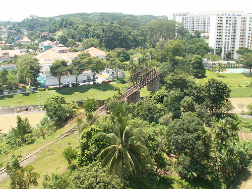
Photo 5: Down in the valley, the old railway track is still visible to the eye

How come I knew so much? Well we had our family outings to Clementi Park when it was first offered for sale by City Developments Ltd in the early 1960s. My 98 year old grand-uncle, who still lives at Sunset Drive, briefed the rest of the family members about his new bungalow. As for me, I was not interested in those adult conversations and was more tempted to watch the railway bridge under construction.

Coincidentally the S. Ulu Pandan railway bridge has a uncanny resemblance to a bridge in the movie, “Bridge On The River Kwai”, especially during sunset and when there are no HDB estates around it. Close your eyes, you can hear “Colonel Bogey” whistled by the POWs.
Recommended Read: Icemoon's follow-up to this article; Old tracks, New Trail: The bridge over the River U. Pandan.

Monday, May 19, 2008

Ulu Pandan Heritage Trail (8) – The bridge that I ‘blew up’ twice (by Lam Chun See)

If you were to travel along Clementi Road in the direction of Bukit Timah, you will cross the Sungei Ulu Pandan near the junction with Ulu Pandan Road. If you looked to the left, towards Clementi Avenue 6, you will see a pedestrian bridge with white canopy. And if you were observant enough, you will notice another bridge a hundred metres or so behind it. This is a black colour iron rail bridge. Have you ever wondered why they built such a strange bridge there? Do you know the history behind this bridge?

Ulu Pandan Railway Bridge - May2008 (22)

Picture 1 - Sungei Ulu Pandan viewed from Clementi Road (in direction of Clementi Ave 6)

Well, I too do not know the history of this bridge. So I will have to leave it to Peter to tell you more about it in the next article. All I know is that a railway track runs across this bridge. (I use the present tense because the railway track is still there as you can see from the photos below) This railway starts at the KTM (Malayan Railway) track somewhere between Holland Road and Bukit Timah Road. After it crosses this railway bridge, it swings to the right running parallel to Sungei Ulu Pandan towards Jurong East direction and ends at a few points in the western end of Singapore; the furthest being at Shipyard Road, near Pulau Sumulun.

Ulu Pandan Railway Bridge - May2008 (15)

Picture No. 2 – View of the railway track crossing Railway Bridge from Clementi Block 305

Ulu Pandan Railway Bridge - 1993 map

Picture No. 3 – Map of the Ulu Pandan Railway Bridge and vicinity from a 1993 street directory


But I do have some close and personal knowledge of this railway bridge because during my active NS days, I took part in 2 exercises to demolish this bridge. The first was when I was attending the Junior Officers Engineers Course at Gillman Camp. The second was when I was a platoon commander in Mandai Camp. I have blogged about the second exercise before, and so today, I will just talk about that first encounter with this bridge.


During my JOE course, the very first exercise; if my memory serves me, was a demolition raid called Exercise Musang (or Mongoose, I am not too sure). As trainees, we hated this type of exercise for two reasons. (1) Such demolition raids were always conducted in the dead of the night, which meant that by the time we returned to camp and cleared the stores and so on, we won’t have many hours left to sleep. (2) Such raids typically ended with a fire fight which meant that there will be casualties to evacuate during the withdrawal phase.

For this particular exercise, our RV (rendezvous) point was at Dover Road. From there we moved on foot to the car park at Sunset Avenue (now occupied by a small shopping mall called Sunset Arcade), formed up and proceeded to set up the charges according to plan. After the bridge and surrounding tracks were successfully demolished, and the enemies killed in the ensuing firefight; the controller called for a halt. This was so that we could dismantle all the dummy charges and detonating cords etc. and pack them onto the 3-tonner. After that the exercise resumed and we had to withdraw with our casualties back to the RV at Dover Road. We took turns to carry the casualties using the fireman lift method. In those days (1977), traffic along Clementi Road was very light after midnight and so we did not cause any traffic jam.


Ulu Pandan Railway Bridge - from Picas 1991 (1)

Picture No. 4 – A 1991 photo of the Ulu Pandan Railway Bridge from the National Archives Collection

Ulu Pandan Railway Bridge - May2008 (12)

Picture No. 5 – A May 2008 photo of the Ulu Pandan Railway Bridge taken from a similar angle

Ulu Pandan Railway Bridge - May2008 (7)

Picture No. 6 – This recent photo shows remnants of the railway track that runs over the now disused bridge.

Besides this exercise we had 2 other demolition raids in our JOE course. One was to blow up the bridge joining Shipyard Road to Pulau Sumulun. This one was quite tricky because we had to lower the men by toggle rope to attach the ‘explosives’ to the pillars.


The third exercise was in Sungei Gedong area. A funny thing happened during the withdrawal stage. A very friendly stray dog ran along with us all the way to the RV point. When we finally departed by 3-tonner, the poor dog was unable to follow us and he looked so sad.

Today I often travel along Clementi Road. Each time I pass Sungei Ulu Pandan and see the bridge in the distance, my mind goes back to that night 31 years ago. When I see the busy traffic along this stretch of Clementi Road, I just cannot picture myself and my buddies evacuating casualties along it.

My …….. how much Singapore has changed in one generation.


P.S. - To get a clearer view of the pictures, just click on it to go to my Flickr account.

Thursday, May 15, 2008

Ulu Pandan Heritage Trail (7) – The famous Kota Tinggi-2SIR Incident: Part 2 (by Peter Chan)

The two photos below were scanned from the book, Singapore, An Illustrated History, 1941 ~ 1984, Information Division, Ministry of Culture.

Top photo notes read: Members of the Second Battalion Singapore Infantry Regiment (SIR) in the jungles of Johor, Malaysia. The SIR was deployed to combat armed Indonesian infiltrators in Malaysia.

Bottom photo notes read: An ambush by the Indonesians at Kota Tinggi led to the deaths of eight SIR soldiers. Suspected Indonesian infiltrators are escorted from a mangrove in Pasir Panjang on 29 December 1964. Local security forces working in close cooperation with British forces succeeded in rounding up many infiltrators and saboteurs and in keeping terrorism generally under control.


***************************************************

As a NS recruit, I did not know much about the Kota Tinggi details but later as a staff officer I had the opportunity to meet these personnel from 2SIR during the usual Friday Tombolo Night.

At that time when Singapore was a part of Malaysia our two SIRs were renamed as 1MIR and 2MIR. 2SIR was operationally responsible for the Singapore and southern Johore area. 2MIR (2SIR) was raised in 1962 and billeted at Holland Road Camp.

According to my superior who was then a young 2LTA in 2 SIR, Dalgit Singh was already a platoon commander, together with LTA Mejar Singh. 2SIR's CO was a Colonel Campbell, a British seconded from the British Army.

It was the crack Indonesian paratroopers from the "KKI", an elite Guards unit from Jakarta which was sent on this mission. The Malaysian police post at Kota Tinggi were alerted of the parachute-landing and the nearest infantry garrison to Kota Tinggi was 2 SIR in Singapore. 1SIR at that time was deployed to the Sabah border with Indonesia.

One platoon of 2SIR was sent inside the jungles of Kota Tingi. For those who have ventured into Kota Tinggi (which I did as a child and as a teenager), it has a waterfall as the key attraction. The killing zone was north of the waterfall.

2SIR made no contact with the Indonesians for about a week. However, unknowingly the Indonesians were tailing one of the SIR sections. Not finding them for a week, that section grew tired and went for a bath at one of the nearby Kota Tinggi streams. Everybody left their weapons at the riverbank with no personnel on sentry-duty.

For those trained in the SAF doctrine, you are not supposed to do this and at all times, your rifle must be with you. The Indonesians pounded on our boys but one injured personnel managed to sneak away and ran for his life into Kota Tinggi Town. All this time, there was "radio silence" because this was a mission. It was only after the injured personnel emerged from the jungle that the incident became known. When the dead were recovered, their bodies were infested with maggots and were very gruesome

Reinforcements were rushed up from Singapore. On that mission were names like James Teo (who was the 5SIR CO for BERSATU PADU in 1971), Jimmy Yap (CO Officer Cadet School), Mahinder Singh (Dy Director SAFTI) and Dalgit Singh (CO 3SIR). They were “young lieutenants” then. James Teo was the unit signals officer. This time, the Indonesians scattered in different directions. It must have been somewhat of a surprise that no Indonesians were caught alive. I leave it to you to guess what must have happened next because I saw some of the photographs taken at that time. Don't forget our jungle-weapons also included the machete. The two Singhs were later involved in the Labis incident and again credited with many enemy killings.

The decomposed bodies were brought back to Holland Road Camp for the Malay burial rituals. The slain men were given a full-military burial.


Photo of the funeral at Bidadari Muslim Cemetery. Men wearing songkok were Malaysian regulars working side by side with their Singaporean counterparts in 2 SIR


##Akan Datang (Coming soon): The bridge that I 'blew up' twice - Lam Chun See


Related Posts:
1) The Famous Kota Tinggi-2SIR Incident Part 1
2) The Famous Haunted Camp

Tuesday, May 13, 2008

Ulu Pandan Heritage Trail (6) – The famous Kota Tinggi-2SIR Incident: Part 1 (by Peter Chan)

It was at our 3SIR Basic Military Training “Rifle Handover” ceremony in 1972 when we first heard about the Kota Tinggi incident. As usual, most fresh “civilian-turned military” conscripts were wondering what so big deal about this ceremony and all about the “AR15”.

The guest-of-honour was Ltc. Dalgit Singh, CO of this Bedok Camp 1 unit. Of course the Hokkien Pengs joked about “Bai-singhs” and making remarks such as "BIG, STRONG & FRIENDLY", probably adopted from a recent Chartered Bank TV advertisement. There were lots of giggles on the parade square. Even the presence of WO1 “Tiger Ong” made no difference. Later that same evening OC Delta Company, a Lta Lau had all of us at the Company Line for “OC Talk” and after that a punitive lesson called “Change Parade”.

1. Dalgit Singh was a young lieutenant with 2SIR credited for single-handedly killing 6 or 7 Indonesians at Kota Tingi in 1965. Most military pilots would score a "kill" by painting a symbol on the aircraft; however this man was very different. He was always quiet and very stern-looking. From that day, “everybody took cover”.

2. We were told in no uncertain terms that if we lost our rifles; be it a part or a whole, sure “kenna big trouble”. Possible punishments often meant DB (detention barracks). It seemed at that time the SAF was bent on instilling a sense of responsibility; especially over weapons. Recently I came to know of a missing rifle by an infantry man in the Mandai Forest area. There was public coverage and many SAF personnel were deployed to find the rifle. I am not sure what has happened to this chap. In my opinion this episode has taught me something deeper than just the rifle. It taught me the significance of personal responsibility over what we do, and being responsible for its outcome - positive or otherwise.

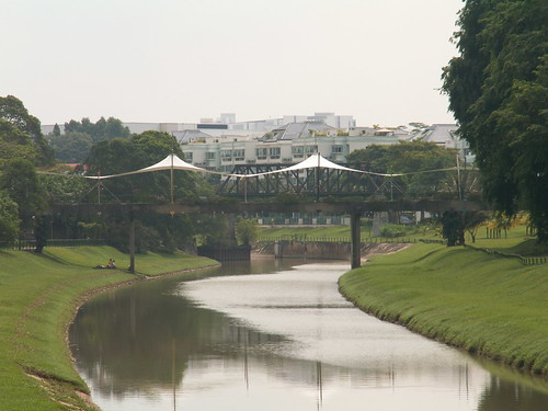
Cadet C S Lam meticulously cleaning his precious AR-15


Photo of a stripped AR-15 displayed at the Army Museum by Acroamatic

To others, you might wonder; “What so big deal?”

The story goes back to mid-1965 when the Indonesian regular army units parachuted into the Kota Tinggi region of Johore, Malaysia. After this incident, there were two other incursions into Johore; a parachute-landing at Labis and a beach-landing at Pontian.

In the next episode, an account of the Kota Tinggi incident and the people involved from 2SIR.
It is interesting to know that when Singapore was a part of Malaysia, 1 and 2 SIR were renamed as 1 and 2 Malaysian Infantry Regiment (MIR). The 4th Malaysian Brigade HQ with overall responsibility of the two SIRS was based at Fort Canning.

Friday, May 09, 2008

Ulu Pandan Heritage Trail (5) – The famous ‘haunted camp’ (by Lam Chun See)

There used to be three army camps along the Ulu Pandan/Holland Road. The first was Mowbray Camp which Peter blogged about earlier.

The second was 1 SIR which was opposite Pandan Valley. According to Peter who used to live nearby; “The original barracks of 1 SIR were built on the hilly terraced slopes of Hill 110 which faced Old Holland Road and its junction with Ulu Pandan Road. The present parade square (at the foot of Hill 200) was not built until early 1962. The single-storey buildings were made from wood and had asbestos roofs. Shortly after independence from Malaysia, some of these wooden buildings were demolished to make way for the present rows of multi-storey concrete buildings facing Old Holland Road. The new buildings were meant to cater to the NS intakes. For field training such as 81mm mortar weapons, the hilly spaces (flattened in the early 1970s to make way for Pandan Valley Condominium) opposite to the camp were used.”


One of the buildings of the camp complex viewed from the main road. Some renovation was going on. I wonder what they are converting this place into. Anyone know?

The main entrance to the camp was from Ulu Pandan Road. But there was a small road leading to it from Old Holland Road. In the late seventies, when squash was a big craze among young Singaporeans, my friend who was an SAF regular brought me there occasionally for a game of squash. I will blog about those old squash courts of yesteryears in another article. 1 SIR occupied the Ulu Pandan site from 1958 through 1969 when it relocated to Dunman Road and it became known as Guillemard Camp. The camp at Ulu Pandan Road was converted into the School for Military Medicine or SMM for short.

This is the spot along Old Holland Road where a small road led into the camp. On the way, there was a ’new’ squash court on the left.

The third camp was 2 SIR. It was located on a small hill and its entrance was from Old Holland Road. I have not entered the camp before but have seen it from the main road. It had several wooden buildings. It was visible from Mount Sinai View.

This is a 1965 Photo courtesy of Peter Chan showing the entrance of the camp. In the background is 1 SIR.

This is a recent shot of the place where 2 SIR used to stand.

This is a recent shot taken from Mount Sinai View of the hill where 2 SIR used to stand. In those days, there were less tall trees and the camp buildings could be seen quite clearly.


And finally I come to the part which you guys are waiting for; the ghost stories. In the early 70’s, there were stories circulating about some army camps being haunted. I was not sure whether to believe them or not, but soldiers being soldiers, it was fun to listen and retell these stories. As far as I can recall, there were five army camps that were rumoured to be haunted. The first was Pulau Tekong Camp (I think it was the camp further inland - cannot remember if it was Camp I or II) where I did one in-camp training in the 80’s. Another was Tampines Camp. The third was the Magazine Tower 2 of Safti (now called Pasir Laba Camp). I myself have done a few guard duties here and never experienced anything worth telling. The fourth was the School of Combat Engineers in Pulau Blakang Mati (Sentosa). The fifth, and most famous (‘spiritwise’) was 2 SIR.

When I doing my Section Leaders Course in Safti after completing my BMT (basic military training) also at Safti, some of my new platoon mates who joined us had done their BMT in 2 SIR. They told us many ghost stories about this place. Unfortunately I can only recall a bit. For example, they said that at night they often heard people moving about in their bunks; but they were too frightened to get up to check. One particular recruit, quite a fat chap, often woke up in the morning to find that his sleeping position had somehow been reversed. I am sorry I don’t remember much else.

My brother David who served as a corporal in the demolition platoon in 2 SIR in 1971/72 used to tell us about one of the toilets being haunted. Apparently the corpses of soldiers who were killed in Kota Tinggi during the Indonesian Confrontation were brought back from Malaysia and ‘washed’ in this toilet. According to Peter, their decomposed bodies were brought back to this camp for the Malay burial rituals. As to what actually happened to those dead soldiers, I will let Peter give you the gory details in the next post.


Recently, I emailed my brother David, who is now in Perth, if he remembered those ghost stories that he used to tell us, and his reply was; Yes, definitely. This is what he wrote:

“2 SIR comprised of 2 camps, divided by a road. Most of the platoons, including HQ, guard house, main parade square were located on one side, while demolition and other support platoons like mortar were in the other camp. Both camps were located on top of small hills.

It was in the smaller camp that most of the so-called "ghost sightings" were made. I was in Demolition platoon, after my section leader course .... that was sometime around 1971-1972.

One of the most common stories was that around late evening, say, 6.30 pm till 7 pm, a young lady in white runs across the road near the canteen. The other story was that people often heard weird crying sounds when they were showering.

I have a true personal experience. It was a Saturday night. I was then on duty (don’t think it was guard duty) and was sleeping on a mattress in the office of the Demoliton platoon. Around midnight, I was awakened up by marching sounds just outside the office .... up and down .... clog, clog, clog ..... I tried to stand up but just could not - maybe my legs went soft. It went on for a few minutes then stopped. I could not sleep for another few hours and was too scared to go out to investigate. Next morning, I checked around to see if there were any soldiers who stayed over the weekend - none .... anyway who wants to stay in camp over the weekend.

Many years later, when i was working for Citibank, I heard from colleagues that the hill where our camp was located used to be execution grounds for Japanese soldiers during WW2. Opposite 2 SIR, in the Moonbeam Terrace hills, it was also another execution and burial grounds during WW2.

The Hokkien soldiers in our support platoons were especially strong believers that the camp was haunted. One private soldier even painted a big picture of a tiger on the wall of one building (don’t know why he was not punished for it ), but he got very sick a few days later. As usual, the other soldiers blamed it on the 'ghosts'.

Well that’s about it, more sounds and rumours actually ...... nothing like what you see in Liao Zhai. However, my personal story is true. In fact it’s the only "encounter" I have ever had in my life.”
PS - I have become a bit confused by the names of the 2 camps and hope some of you can clarify. Was 1 SIR known as Ulu Pandan Camp and 2 SIR known as Holland Camp?

Saturday, May 03, 2008

Ulu Pandan Heritage Trail (4) – The Short and Winding Road (by Lam Chun See)

If you had to vote for the most ‘winding’ road in Singapore, which would it be? South Buona Vista Road perhaps? My choice would be Old Holland Road. Do you know where that is?

Photo shows where Ulu Pandan Road (left) joins Holland Road (right)

Old Holland Road is actually a side road that joins Ulu Pandan Road and Holland Road. However if you check the street directory, it is listed as Holland Road. But I am very sure it was formerly called Old Holland Road and it led all the way to Bukit Timah Road near the Komoco/Hyundai showroom and opposite the Swiss Club Road. There are a lot of big private bungalows as well as old trees and sharp bends along this short and winding road.

However, this short road has been shortened even further a few years ago. It is now truncated by a huge piece of empty land which I blogged about here. Thus the short and winding road suddenly ends where it crosses a canal.


This is the part where the Old Holland Road was truncated. That short stretch behind the barrier used to lead all the way to the Bukit Timah Road via a winding route that passed through thick vegetation. I used to jog here quite often.

The road in the foreground used to be called Holland Lane and it led to Chinese cemetery and an old temple. Very quiet and eerie. Below is a photo of that temple taken from the National Archives collection.


Today the road is renamed Holland Plain and the temple is called Fong Yun Thai Association (see photo below). Just in front of the entrance to this temple complex, the road makes a 90 degree turn and becomes Holland Link which rises steeply till you come to Old Holland Road again. With this development, I guess they have no choice but to rename the front portion of Old Holland Road back to Holland Road as in the sixties.


Very interesting (and confusing) indeed. I often do my brisk walking exercise here and on more than one occasions encountered drivers who had lost their way; including a couple of taxi drivers!

I used to wonder why this road was called Old Holland Road when it looks more like a side road joining the main road; and it seems as if Holland Road and Ulu Pandan Road are actually one continuous road. I believe some of you may not even know where Ulu Pandan Road ends and where Holland Road begins. But looking at a 1964 street directory, it becomes clearer. In those days, Holland Road and Old Holland Road were one continuous road called Holland Road and Ulu Pandan Road was a side road. According to Peter Chan, it was a non-metalled track which started at Reformatory Road, the old name for Clementi Road. This track was to serve Mowbray Camp which existed prior to WW2.

All the above is only my hypothesis. I hope some reader familiar with this part of Singapore can confirm.

At the junction where the old Old Holland Road joined Ulu Pandan Road and Holland Road (see photo no. 1 above), there used to be two army camps. One was 2SIR which was on the small hill. My elder brother David used to serve his NS (National Service) in the early 70’s here. The other was 1SIR.

Of these two camps, 2 SIR was the more interesting one. A number of interesting ghost stories originated from here. Want to know more. Look out for our next installment coming up soon.

Thursday, May 01, 2008

Ulu Pandan Heritage Trail (3) – Mowbray Camp (by Peter Chan)

Mowbray Camp was originally a gun detachment of the Buona Vista Gun Battery. This gun battery detachment was responsible for the defense of the western section of Singapore during WW2. There is a secret tunnel that runs from one of the buildings inside Mowbray Camp down to the valley in the forest beside the camp (currently under lock). Down in the valley was a narrow-gauge railway track that formed a part of the British Military railway transport system.

The original camp area was much larger than it is today. The present Clementi Road, just before turning left into Ulu Pandan Road, was once a road within the military compound before it was acquired for road widening in the 1950s. The seafood restaurant across the camp was once a “Radio Taxi” stand in the 1960s. It was set-up to meet the needs of the British Military. The booth covered the geographical areas of Dover Road, Sussex Estate and Clementi Park. A unique practice of making a booking for a taxi meant you had to search for a specific telephone number of the “Radio Taxi” stand nearest to where one lived; in this case the taxi stand opposite Mowbray Camp. You could not expect a “Radio Taxi” stand in Jalan Jurong Kechil, King Albert Park or Holland Village to dispatch one of its taxis. Thus the present system of calling through a hotline, e.g. 65551188 is certainly better than the old system.


Fig 1: The former Mowbray Camp’s main entrance

The prevailing use of Mowbray Camp as a guard unit is something historical. After WW2, it became the home of the #3 British Army Guard Unit and in the 1960s home of the #5 Gurkha Dog Company. Armed guards and dogs were dispatched from here to various British Army camps and bases for duties. Although this facility was run by the British Army, it did not provide for security cover for RN and RAF bases. Very often when I passed this way on my way to town, I could hear dogs barking during their morning training. I was informed that even dogs also have their own “5BX” and these animals thoroughly enjoyed their daily training schedules.


Fig 2: One of the pre-WW2 buildings at the highest point of Mowbray Camp (circa 1958). It was used as a football pitch but the SAF converted that into a “Parade Square”. The secret tunnel was somewhere around that building

Between 1971 and 1974, it was used by ANZUK forces, the Commonwealth Forces of Australia and New Zealand that replaced the British Military. After the SAF took over in 1974, it became the SAF Provost Unit. Different SAF Provost units were based here including SIB, School of Provost, APC, SC and DB. The SAF also shared the facility with the Singapore Police Force before vacating it completely in 2003 for Kranji.


Fig 3: Gurkhas and their guard dogs

Saturday, April 26, 2008

Ulu Pandan Heritage Trail (2) – Pandan Valley (by Peter Chan)

I don’t usually follow any of our locally-produced TV drama serials; be it English or Mandarin. The first and only time I did was “Masters of The Sea”. Who could forget Koh Cheng Mun’s “I’ll crush him like a cockroach”. So it was a pleasant surprise when I came across “En Bloc”. That the drama has the lovely Andrea Fonseka is not the reason. I quickly recognized a few familiar landmarks. “En Bloc” was filmed using the backdrop of Pandan Valley, a condominium off Ulu Pandan Road. Lim Beng Teck’s Minmart was certainly on the void deck of Eugenia or Chempaka Court.

Pandan Valley was the first private condominium built in Singapore and developed at the height of the property boom in 1975. It was left vacant until 1978 when the project was re-launched by DBS Land, the property arm of DBS Bank. Somehow Pandan Valley never gained popularity with expatriates or upper middle-income Singaporeans. Those people preferred Ridgewood, a condominium located behind Pandan Valley. Could it be the case that Pandan Valley was lying in District 21 and Richwood in District 10?

There were many other differences between Ridgewood and Pandan Valley. Ridgewood was built and owned by Dillingham Inc. Ridgewood offered a Hawaiian theme for its architecture and the garden-landscape, whereas Pandan Valley had largely a strong “Singaporean” influence of Spartan interior finishes and large floor spaces. The cheapest unit in Pandan Valley was priced at S$98,000 with tower block penthouses going for S$280,000 at that time. Pandan Valley was a mixed development, a first concept for any private sector housing project in Singapore. It had both retail space and residential units. There was the Yamaha Music School at the block nearest to Ulu Pandan Road.


Fig 1: Pandan Valley viewed from Jalan Jelita (circa 1977). The block on the extreme left is Ridgewood

Fig 2: I am standing in the open space between Poinsetta Tower and Poinciana Tower (circa 1979)


Fig 2A: The swimming pool at Pandan Valley (circa 1979)

Before Pandan Valley was built, it was a hilly terrain with low vegetation. It was frequently used as a training area by 1 SIR in the early 1960s. 1 SIR was the original “tenants” of the former School of Military Medicine.

Fig 3: The hills opposite 1SIR which would become the future Pandan Valley (circa 1958)

Will Pandan Valley go through an enbloc sale? Stay tune every Wednesday on Channel 5 as the drama unfolds.

Thursday, April 24, 2008

Ulu Pandan Heritage Trail (1) – Pine Grove Vicinity (by Peter Chan)

Land is a much sought-after asset in Singapore, so much so that even cemeteries were converted for public housing. Many of the older cemeteries became sprawling HDB estates. When Singaporeans became more affluent by the mid-1970s, there was a new form of public housing called “HUDC”. HUDC housing was offered in phases, the first phase at Laguna Park but for me I joined in the queue under Phase 3. The estates under Phase 3 included Gillman Heights, Bedok Reservoir and Pine Grove. Unfortunately I was not able to live in any of those HUDC Estates because the stork had arrived early and there was a pressing need to acquire my roof as soon as possible.

How many of us really knew the original land use of Pine Grove; which is located off Ulu Pandan Road?

I used to travel very frequently from my house to town using the Ulu Pandan Road. Ulu Pandan Road was a very quiet place with very few developments. The only prominent landmarks were at 1SIR, 2 SIR and Mowbray Camp. So I could never miss the serene sight of this military cemetery. Even without the photos, I could still visualize the entire cemetery.

The Ulu Pandan Military Cemetery was one of two cemeteries operated by the British Military, the other was at Dover Road next to an Anglican church. The Ulu Pandan Cemetery was first opened in 1955 and contained over 1,500 remains of British Servicemen of the 3 services (British Army, RAF and RN), civilians employed by the British Military and their families whilst serving in Singapore. It had a small white chapel to the left of the entrance. It was a multi-religion cemetery containing separate burial plots for Catholics, Protestants, Hindu and Buddhist religions. By 1968, the remains were transferred to the Kranji War Memorial.

Here are some early 1960s photos of the Ulu Pandan Cemetery.


Fig 1: A military burial ceremony at the main entrance to the cemetery. The view is from the cemetery towards Ulu Pandan Road.

Fig 2: The graves and the chapel in the background

Fig 3: The small chapel on the left of the main entrance. Beyond the gate were the graves. The old chapel could be on the slope of the Pine Grove main entrance