Showing posts with label Queenstown. Show all posts

Monday, April 13, 2015

My Queenstown Heritage Trail – Dawson & Alexandra Tour


Last Saturday, I was invited to the Media Preview of the newly-launched Dawson + Alexandra Guided Tour. This tour is part of the My Queenstown Heritage Trail.


We assembled at the Queenstown MRT Station at 8.30am. I was happy to see several Foyers (Friends of Yesterday.sg) like Pei Yun, James Seah (Thimbuktu), Philip Chew and KL Lee. After the usual greetings/briefing by the organizers, Kwek Li Yong and Mr Jasper Tan of My Queenstown Community, we were divided into 2 groups led separately by volunteer guides, Mr Choo Lip Sin and Huang Eu Chai. We were each issued with a copy of the very well-produced My Queenstown Heritage Trail booklet which contained 67 pages of photographs and historical information about Queenstown. We were also handed a very cool gadget called Vox Radioguide. This device enabled us to listen to our guide’s explanation via normal earphones even when he was some distance away.


Briefly, the itinerary of our tour was as follows: (Due to time constraint, we did not cover all the places listed in the official flyer).

1) Church of the Good Shepherd at Dundee Rd

2) Former Forfar House at Strathmore Ave

3) Princess House at Alexandra Rd

4) Walk along Dawson Rd, Margaret Dr to Bunkers at Kay Siang Rd

5) Take coach to Tiong Ghee Temple at Stirling Rd

6) Butterfly Block (Blk 168)

7) Walk to Alexandra Hospital, passing the Alexandra Fire Station and Queensway Shopping Centre

8) Back to Queenstown MRT Station by coach.

Here’s my brief report on some of the more memorable places for me.

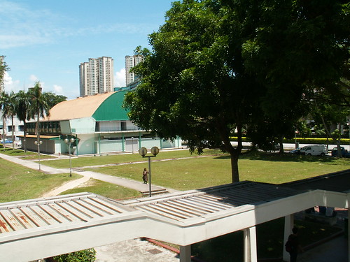
1) Queenstown Driving Centre.  Although this was not part of the tour, this place was highly visible from the MRT Station. It held special memory for me as I took my driving test here more that 40 years ago when I was still an undergraduate. I blogged about it here. I was quite sad to learn recently that this place will be demolished soon to make way for yet another condo.


2) Former Forfar House.  Actually, I am not familiar with this place or its history, although the name Forfar House was quite well-known in the old days. I came to know about it from a book titled, From the Blue Windows, written by a former resident, Tan Kok Yang, who I met at the My Queenstown Symposium held at the Queenstown CC on 26 May 2013.

3) Princess House. Our next stop was the Princess House. This building is a prominent landmark along Alexandra Road. It was gazetted for conservation in 2007. Besides the information given by our guide, my friend Philip Chew also shared some of his memories from the early 1970s when he worked at the Ministry of Environment which was housed here. He also told us about the nearby Consumer Co-operative Club.


4) World War 2 Bunkers at Kay Siang Road. The next event on the itinerary was to see two World War II bunkers at Kay Siang Road. They were hidden amongst the thick vegetation just next to the former Hua Yi Secondary School. To get here, we had to walk along Dawson Rd and parts of Margaret Drive and Kay Siang Rd. It was sad for me to see that Margaret Rd has been changed beyond recognition. It has recently been realigned to join Kay Siang Rd. Previously these two roads were not linked as you can see from the 1981 map below.


I was also saddened to see that the Hua Yi School had been completely demolished although we could still see remnants of the school field and running track. I had driven pass this place many times, and had often wanted to stop and take some photos. But as usual, I kept procrastinating, and now the opportunity is lost forever.

It was interesting to note that there are still some black and white bungalows along Kay Siang Rd although they are not visible from the main road. By the way, mention of Kay Siang Rd always brings to mind my first visit to the MOE (Ministry of Education) in 1968 to obtain the application forms to enrol in the Singapore’s first junior college, NJC, which opened its door in 1969.


This does not look like a bunker to me. I suspect it’s an ammo dump; probably to service the nearby Buller  Camp. Buller Camp was built to house Japanese prisoners of war. It was located at Buller Terrace (see map)

5) Tiong Ghee Temple. Our next destination was the Tiong Ghee Temple nestled among old HDB flats at the top of Stirling Road. Did you know that this used to be a hill known as Hong Lim Hill because the land originally belonged to philanthropist, Cheang Hong Lim?  We met two elderly former residents who shared their memories of life in this part of Singapore. As expected, this used to be a kampong known as Boh Beh Kang. Across the road were Singapore’s first point block flats.

6) Butterfly Block. A stone’s throw away was the famous Butterfly Block of Queenstown. This is Block 168, which is easily seen from Queensway, a road I have travelled frequently for decades. Here we met Mr Fernandez who had been living here for 45 years. I was happy to hear him confirm my memories about the Rumah Bomba Circus which lay at the junction of Queensway and Alexandra Road. I remember going to having my haircut at a road barber shop which was located at the edge of this roundabout. We also shared fond memories of the attractions at Queensway Shopping Centre, especially Jumbo Coffee House. I too have blogged about Queensway Shopping Centre here.

Butterfly Block at Stirling View

With Mr Fernandez - resident of Butterfly Block
7) Alexandra Hospital. We proceeded on foot to our final destination -  Alexandra Hospital. On the way, we passed the busy traffic junction where the Rumah Bomba Circus used to stand. Of the four landmarks that surrounded this junction, Alexandra Village, Safra Clubhouse, Archipelago Brewery Company (which I used to know as Anchor Brewery) and Queensway Shopping Centre, only the last one was still standing. It will be a sad day indeed, when the bulldozers come along and do what they are so good doing in ever-changing Singapore – tear down memories of the Singapore we grew up in.


At Alexandra Hospital, which was originally known as the British Military Hospital, our guide gave a lengthy explanation of history and events that took place in that area during the war; such as the massacre of British troops by the invading Japanese army. I was happy to see that many of the old buildings have remained untouched externally; but my attention was drawn to what lay across the fence; an open piece of land that used to be home to several blocks of SIT flats. This was Queen’s Crescent. During my NS days, I used to date a girl who lived here.


I have enjoyed this tour very much. I thank My Community for organising this tour and advise our who are interested in Queenstown to sign up of this and other tours in the My Queenstown Heritage  Trail series.
 

Wednesday, November 12, 2014

Memories of Queensway Shopping Centre

It is sad to see many parts of Queenstown that I have been visiting for decades disappear one by one. When I was living in Farrer Road, I often went to Queenstown for my shopping and leisure needs.

Even after I got married and moved to nearby Sixth Avenue, my family continued to go there regularly. Among the places that we frequented were the wet market at Tanglin Halt, Queenstown Library, the NTUC Fairprice Supermarket and Big Bookshop at Margaret Drive, Margaret Drive Hawker Centre, Tah Chung Emporium, the BP petrol station at Queensway and Queensway Shopping Centre. Most of these places have disappeared but Queensway Shopping Centre is still a landmark in that part of Queenstown; but I suspect that its days are numbered.


My earliest memory of Queensway Shopping Centre was in the mid-1970s when I was still doing my National Service. I remember going to a Malay barber who was operating from some makeshift stalls at the fringe of Rumah Bomba Circus just before returning to camp on Sunday evening. I think, at that time, Queensway Shopping Centre had not been built yet. Subsequently, after Queensway Shopping Centre was completed, these stalls moved into the complex and I continued to patronize the Malay barbers there. But when my favourite barber, a quiet, gentle old man by the name of Din retired, I stopped going.

Besides the barbers, I also became a regular customer of a tailor there called Benz Tailor until today. I cannot recall how I came to know this shop which is run by a gentleman by the name of Simon. 

During my NS days in Mandai Camp, our S1 (Manpower Officer), a Lieutenant Tay introduced us to a spectacles shop there run by his relative. Other than that, there are the famous photocopy shops on the third floor.

At one time when LDs were the rage, I signed up a membership with a video rental shop at the 3rd floor. Subsequently, the shop closed and moved out before I could redeem all my coupons. Also on the 3rd floor was Christian book store. I bought some books and CDs here. And I also bought some CDs from a shop on the ground floor; including this Bread CD.

There was also a Jumbo Coffee House on the 3rd floor which served pretty good western meals. You can see the name of the restaurant in big letters on the glass window facing Queensway. 

When I was working at the National Productivity Board in Bukit Merah Central, I had to pass by the Queensway Shopping Centre on the way home. Sometimes, I would stop here to buy some kueh tutu and muah chi for my children to snack at night.  It’s fun to watch them prepare the snack. Makes one feel like a kid again.

Another thing I remember about the Queensway Shopping Centre was the basement carpark. The layout of the parking lots were rather strange, like in concentric circles. The entrance is from Queensway and the exit is at Alexandra Road. Exiting the carpark is rather difficult especially if you drove a manual gear car as you have to stop for a long time for the heavy traffic at Alexandra Road.

Today, I seldom go to Queensway Shopping Centre. I feel out of place there with the many shops selling sports goods and shoes and the loud funky music. Still I will miss the place when they finally demolish it.

Friday, May 24, 2013

My Queenstown Symposium (26 May 2013)


Dear friends,

I will be participating in the My Queenstown Symposium on Sunday, 26 May, 2.00pm, at the Queenstown Community Centre. I will be making a short presentation of my memories of Queenstown. As you should be aware, Singapore’s first HDB estate has been undergoing drastic transformation these past few years. Many of the iconic places in this lovely little town have disappeared. Although, I have never lived in Queenstown, I have stayed near to it for most of my adult years; and hence have many happy memories of it.

Other speakers at this even include my friends, Lai Chee Kien and Yu-Mei Balasingamchow. For more details (you have to register), please visit their Facebook page here.

For those who have yet to purchase a copy of my book, I have good news. The organisors have kindly given me permission to sell my book at this event. You will be able to get it for only $10 instead of the usual retail price of $18.65. So I look forward to seeing you there. 

Recognize these places?

Thursday, November 10, 2011

Then and Now – Queenstown Library

The answer to the Old Building Quiz No. 16 is: Queenstown Library. The black and white photo is of the proposed site of the Queenstown Library at Margaret Drive. I saw this photo at the National Archives website a few years ago; but when I try to look for it now, I am not able to find it any more. So I am not able to tell you the date of the photo. I trust that I have not made a mistake. I hope some of the older readers who are familiar with the old Margaret Drive can confirm that this photo is indeed of Margaret Drive.


The second photo technically is not a ‘Now’ photo because I took it about 2 years ago in October 2009. Among all the public libraries, Queenstown Branch is my favourite. I have been going there for decades. I can remember clearly what the layout was like before the renovation. As you entered the library, there was a broad staircase on the left leading to the second storey, the Adults Section. Straight ahead were the service counters; and to the left would be the Children’s Section. My children spent many hours there when they were small.

Here’s another shot of the Queenstown Library taken from an angle that you are unlikely to be able to do now, or ever again. I took this photo from the multi-storey car park next to the NTUC Fairprice Supermarket. This car park was recently demolished together with everything else around it. In a few years’ time, you will see a completely new Margaret Drive.

I know many Singaporeans harbour fond memories of the old Queenstown, especially Margaret Drive. My earlier post about this area drew an incredible 80 comments! I hope this article has stirred up your memories of the old Queenstown Library. Do share them with our readers here. You can also share them with other Sinaporeans at the Singapore Memories Project website here.

Related Post: Gather moments while you may.

Thursday, June 18, 2009

Where was the Baharuddin Vocational Institute?

My recent article about the mysterious shooting incident in Queenstown and the subsequent discussions of the exact spot of the shooting reminded me that the nearby MDIS campus used to be called the Baharuddin Vocational Institute. I expect that many of the younger readers have not even heard of this name. Interestingly, a check with my many old street directories showed that this campus has been occupied by a number of different educational institutions. For example:

1981: Baharuddin Vocational Institute
1993: Temasek Polytechnic (Stirling Road Campus)
1998: ITE Bukit Merah (Campus 2)
2001: Queenstown Vocational Training Centre
2007: MDIS University Campus

Are you amazed and confused by the different names? I certainly am. But I am too lazy to go and research this subject. All I know is that the ITE, which stands for Institute for Technical Education (and not It’s The End), was formerly called VITB, or Vocational and Industrial Training Board; which itself was formerly called STI, or Singapore Technical Institute. I think the first name in my list, BVI was probably a part of the VITB. As for the 4th name – QVTC, this is the first time I come across it.

I think I‘d better leave it to our retired teacher, YG to blog about this bit of history and not confuse readers with my speculations.

As you know, our government is very fond of re-branding and changing names of places and institutions. That gives rise to a lot of confusion among the younger generation. For example, the other day, I was driving my youngest daughter to Hougang. I noticed that she pronounced the name How-Gung (as in ‘how are you?’ and gung-ho). I corrected her saying that she should use the hanyu-pin (Mandarin) pronunciation and explained that the place was originally called Ow Kang which was a Hokkien pronunciation.

Another example is Safti. Like me, my son is now going through OCS training in Safti; but the confusion is that his Safti and mine are two different places. Mine is just down the road and had its name stolen and now has to bear a less glamorous name called Pasir Laba Camp.

Anyway, I shouldn’t be criticizing the government because I myself am guilty of causing this type of confusion by giving my children both dialect and pinyin names. Hence at home we call them by their pinyin names whilst in school they are called by the dialect names (though mispronounced) and in church it’s a mixture; to the extent that a girl asked my daughter recently, “How come your brother’s name is so different from yours?

Anyway, as always, I have digressed. Let’s take a look at this 1981 map of the Queensway/Tanglin Halt area. Practically every major landmark there has changed.

The Queenstown Circus is no more. In its place, are a traffic lights junction and an underpass.


Most of the schools around it have been either vacated or rebuilt. The mosque has been rebuilt I believe. I am not sure about the Queenstown Community Centre. (Strange – I thought they have all been renamed, or rather re-branded, community clubs)

The Queenstown Police Station was vacated some years ago. It was replaced for a time by another uniformed organisation. Do you know its name? That too moved out, and now it is occupied by a student’s hostel.

Across the road, there used to be a Police Reserve Unit. Now the signboard says, Police Special Operations Command.

But this church and Hindhu temple along Commowealth Drive haven’t changed much.


Likewise this row of flats at Tanglin Halt Road. But how long will they last, I wonder?

Tuesday, June 16, 2009

Seeking your views about Queenstown heritage project


I received an email from a group of Innova Junior College students.

“My group is taking on a project regarding the conservation of Queenstown's history. Through our project, we intend to educate more Singaporeans about the significance of Queenstown as a historical landmark.”

Among their questions are these two which I hope readers; especially those who know about the history of Queenstown, can help them out with some inputs. Thank you.


1. What are your views on the redevelopment of Queenstown?

2. We would like to propose a heritage gallery cum mini cafe to showcase Queenstown through the ages. Do you have any suggestions on how we could further improve on this idea?

Thursday, April 30, 2009

Mysterious Shooting Incident in Queenstown

Any shooting incident in this little country of ours which has one of the strictsst gun laws in the world is always big news. But what makes the incident that I am about to narrate truly unprecedented and bizarre even is that it happened in broad daylight.

It happened around noon time in Queenstown, 18 September, 1972. A 22-year old seamstress by the name of Cheng Li Zhen (曾丽珍) was walking with her 19-year old sister Li Bao (丽宝) somewhere along Queenstown (I think it was Margaret Drive) when she suddenly gave a scream and collapsed on the ground. Blood was oozing from her chest. It was only after she was sent to the Singapore General Hospital that they discovered she had been shot. She died from her wound without regaining consciousness. She was from a small Malaysian town called Kluang.

I remember reading some criticism being levied against the policemen on the scene for being too shy to examine the wound which on her left breast; and thus not even realizing that it was a gunshot wound.

It was really big news at that time. And it is only recently that I was able to recall more details about this case because a friend gave me a copy of the Sin Min Daily’s 40th Anniversary Commemorative publication, and this was one of the archive items mentioned. I have tried searching for it at the National Library’s Straits Times archives but was not successful. Hope one of you readers can help out and let us have the link to any news articles about this case.

Anyway, X-ray showed that the bullet entered from her upper left chest and hit her heart. Initially, the police classified the case as ‘murder’, and suspected that the shooter was a sniper hiding in one of the high-rise buildings around Queenstown Circus or Stirling Road. Later, they confirmed that the bullet was a .22 calibre round and was probably fired from close distance from a handgun. But the trouble is, there were no witnesses and her sister did not see any shooter.

Another theory was that the round was accidentally discharged from a passing vehicle. Yet another theory that I recalled reading was that the round has gone off a weapon from the nearby Police Reserve Unit in Queensway when somebody was cleaning his weapon.

The case was later re-classified as an accident as the victim did not have any enemies and her family simply cannot think of anyone who would want to harm her.

Thirty-seven years have gone by and the case remains a complete mystery.

Friday, April 03, 2009

Commonwealth Drive

I am surprised that my earlier post about Margaret Drive in Queenstown attracted many comments. It appears that many former residents who grew up in this old HDB estate still harbour fond memories of it. So I am motivated to write another post about Queenstown.
If you are not familiar with Queenstown and you were given an address in Commonwealth Drive, then I should warn you to be careful. You’d better check your street directory before you set out. The reason, as you can see from this 2007 map, is that Commonwealth Drive is truncated into 2 sections by the East-West MRT Line and Commonwealth Avenue. So if you went to the wrong section, you would have to make a big detour, and if you are not familiar with this area, you will definitely get lost.

At Tanglin Halt, there is an old hawker centre (Blocks 1, 2 and 3) that I used to frequent. When I went there recently for lunch, I noticed that the place looked run-down and deserted. Many of the stalls were empty. I guess they must be about to redevelop this place; and so I took some photos with my handphone camera (which explains the poor quality).

When my kids were young (this would be in the early 90’s), we liked to come here for dinner. We frequented one zhi char stall near the children’s playground. In fact, the owner knew us so well that once we went off without paying but the she wasn’t worried at all. Usually, whilst we waited for the food to arrive, my children would play with the facilities in the playground and were reluctant to come back. I guess that is one of the drawbacks of staying in a small private estate. Unlike the private condominiums and HDB heartlands, there are no children’s playgrounds in the vicinity of my home.
Let me end with a quiz about the old Queenstown. See this photo of the PUB gas tank (from the National Archives collection)? Can you tell me where exactly it used to be located?

Saturday, August 25, 2007

Gather Moments While You May

In writing this blog, one of my biggest frustrations is that I do not have the photos to illustrate the places I try to describe. For example, I wrote about the cemeteries of Pek San Teng or Kampong San Teng before it was converted into Bishan new town. How I wish I had some photos of what it used to look like – the hills with rows and rows of tombstones, the pavilions and even the traffic jams that took place every Qing Ming.

Many young people of today have no idea what Singapore looked like one generation ago. In his National Day Rally speech, PM Lee Hsien Loong announced exciting plans to transform Singapore. Add to that the ongoing Enbloc madness, and I fear that the next generation of Singapore will also have little idea of what Singapore looks like today; especially the many lesser known places.

Let me give you an illustration. I was at the Queenstown Library the other day and parked my car at the multi-storey car park next to NTUC Fairprice supermarket. I noticed that the car park was practically empty. The reason was obvious. Many of the nearby shops have either disappeared or shut down. Before long this place will be transformed beyond recognition. Fortunately, I had my camera with me and managed to capture some shots for you to enjoy. But unfortunately, the batteries ran out after a while.

Anyway, the point I am trying to make is this. Take the advice from Paul Anka’s song, Times of Your Life and “gather moments while you may”. Take out your digital camera and take some photos of places in your neighbourhood that you think will be gone soon. Better still; do what my friend Kenneth is doing and document them in your blog. Your children will thank you for it.

OK. Enough words. Here are some photos of Margaret Drive in Queenstown, taken on 23 August 2007. Enjoy them because they will be gone before you even notice it.


PHOTO #1 – Hawker Centre
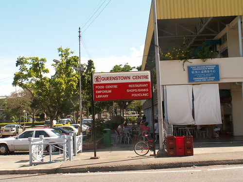
Margaret Drive - signboard

This signboard is next to the Hawker Centre. Three of the 6 items listed are no more: the emporium, shops/bank and restaurant.

This is a very old hawker centre. The most famous stall here is the fish ball noodles stall. On the upper floor, there used to be a POSB branch.


PHOTOs #2 and #3 – Emporium

Margaret Drive - Emporium1

On the left is a wet market and on the right is the hawker centre. There used to be a 3-storey building (Block 40B) in between. Top floor was a Chinese restaurant famous for its tim sum. I think it was called Golden Crown. They were relocated to the Safra branch at Bukit Merah. They had an outlet selling tim sum on the ground floor. I used to buy from them when I had a gathering at my home. On the second floor was a Chinese emporium. On the ground floor was a coffee shop and a Mont’ Dor cake shop. Here’s another shot taken from the hawker centre.

Margaret Drive - Emporium2


PHOTO #4 – Cinema and Bowling Alley
Margaret Drive - Queenstown Cinema1

This building is just next to the NTUC Fairprice supermarket. It used to house 2 (I think) cinemas – Queenstown and Queensway; Plus a bowling alley and a KFC restaurant.


PHOTO #5 – Churches
Margaret Drive - Churches

On the left is the Fisherman for Christ church and on the right is the Church of Our Saviour. Do you know that both buildings used to be cinemas? The one on the right was called Venus; but I cannot remember the name of the one on the left.


PHOTO #6 – Banks

Margaret Drive - Maybank

This photo shows the hawker centre at the top. Previously there was an HDB Block 40 blocking your view. On the ground floor, right hand corner was a Standard Chartered branch. To the right, at right angles to Block 40, next to the car park was Block 39. On the ground floor, at the corner was a Maybank branch. I used to have an account with them. Further to the right, on the other side of Margaret Drive would be my favourite National Library branch; the Queenstown branch. Along that stretch of road, there used to be many HDB apartment blocks. They have all been torn down. There are now only 2 blocks left. One of them is Block 39A.


PHOTO #7 – Block 39A

Margaret Drive - Blk39A(1)

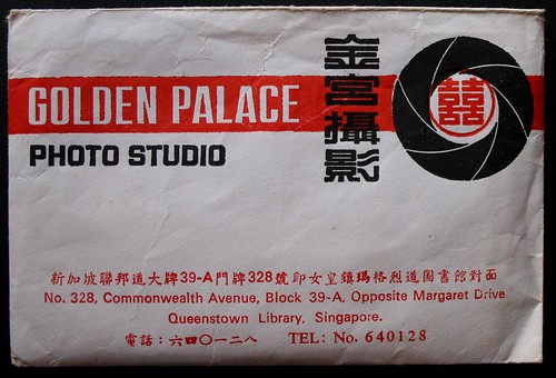
There used to be many shops at the ground floor including one photo studio called Golden Palace. Notice that their telephone number has only 6 digits.

Photo Studio - Golden Palace

Please feel free to download these photos and add them to your collection. You may want to show them to your grandchildren one day.