If you traveled along Bukit Timah Road from Hwa Chong Institution towards Clementi Road, you will pass a number of side roads that go by the names First Avenue, Second Avenue and so on. The most famous of these is Sixth Avenue. By the way, you won’t be able to see Fifth Avenue because it is actually off Sixth Avenue and not Bt Timah Road.
Recently, Sixth Avenue was in the news for the wrong reason. Two United World College students were killed in a tragic accident when their sports car crashed into a wall and burst into flames.

Prior to 1986, I seldom used Sixth Avenue. The only thing I knew about Sixth Avenue then was that there was a very steep slope at the junction with Holland Road, and your clutch control skills would be severely tested if you had to stop there. In those days, there were very few cars with automatic transmission.
Question: Now I want to test your knowledge of this part of Singapore. Have you heard of a place called Race Course Village (and not Bukit Timah Village as I said earlier)? Do you know where it was located?
Answer: Race Course Village was located at where I am staying now; Lucky Park. (Bukit Timah Village was located at the junction of Upper Bt Timah Rd and Jalan Jurong Kechil, where the present market and hawker centre is)
1) Lucky Park
Where I am staying now is a small estate made up mainly of terrace houses and semi-detached houses. An interesting feature about this estate is that all the roads are named after flowers beginning with the letter L. It’s such a small estate, I think I can rattle off all the names - Lily, Lantana, Lasia, Lemon and Lotus. The proper name of this estate is Lucky Park; but somehow nobody uses the name.
Did you know that before this estate was built, it was a village by the name of Race Course Village? I stumbled on this interesting fact when I was looking through a 1969 street directory recently. When I first moved here in 1986, Royal Ville, which is directly in front of my house was just being constructed, and it was a big nuisance for us during the first few years. At that time, there were still a couple of kampong houses remaining right at the end of Lily Avenue, next to the big drain. But today there is only one kampong house remaining. Yes - I am not pulling your leg. And here’s the proof.
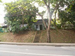
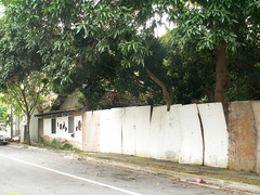
Well actually two if you included this one which is just across the road.
2) Guthrie House
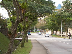
One of the most prominent landmarks of Sixth Avenue today is the Guthrie House with the Cold Storage Gourmet supermarket on the ground floor. Next to it are two new condos by the names of Fifth Avenue Condo and Sixth Avenue Ville. Do you know what was here before? It used to be a furniture factory and showroom by the name of Actus. After Actus moved out, it was occupied briefly by another furniture company called Novena.
3) Cemetery
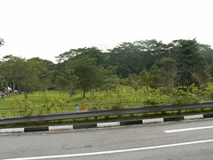
Did you know that there used to be a Chinese cemetery along Sixth Avenue? Off Sixth Avenue, somewhere midway between Bukit Timah Road and Holland Road is a short little road called Lorong Panchar. There used to be a Chinese cemetery here, and next to it was a nursery called Evershine Nursery. Today, both the cemetery and nursery are no longer there. It’s just a green field (see photo below). But a short distance away, at Holland Link, there is still a private columbarium call Fong Yun Thai Association Columbarium.
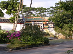
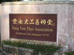
Like many parts of Singapore, Sixth Avenue has undergone much change during the past 20 years. For one thing, the traffic is so heavy nowadays. There are many new condominiums here and even a new road that goes by the very exotic name of Laurel Woods Avenue. But one good change was the relocation of the nearby Turf Club to Kranji bringing with it those irritating weekend traffic jams and even more irritating punters who liked to park their cars in our estate and litter and speed. For some reason, they liked to arrive late and leave early.
Interesting Links
1) A nice arial photo of Bt Timah area showing the old Turf Club can be seen here at a document called BUKIT TIMAH 1993 Planning Report by the URA.
3) “In 1859, one village near Bukit Timah was abandoned due to too many attacks. Bukit Timah was nicknamed A Tiger Resort.” (From Singapore Infopedia)
3) “On the 11th February, Bukit Timah Village was captured. Indian and Australian troops being pushed back, the British abandoned their headquarters at Sime Road and retreated to underground bunkers at Fort Canning. “ (From Radio Singapore International)




24 comments:
Let's see what I can recollect:
1. There is a white building on the Bukit Timah Road side after you cross over from Eng Neo Avenue. In the 1960s it was a British Army Workshop before it was turned over to the Singapore Police Force which used it to repair the police cars and radio sets.
Just after this military workshop was a row of single story shops. Manry grocers were in that place supplying to the British Servicemen who lived in the Bukit Timah area
2. I took United Bus Company #200 from 7 ms Upper Bukit Timah Road through Sixth Avenue. #200 continued all the way to Portsdown Road via Holland V. just in front of Chip Bee Estate
3. There is a Malay mosque at Jalan Alias (did i get the spelling correct??). The Ulu Pandan CC was at the corner of Coronation Road West and Jalan Alias. Today it is an empty piece of land. My good friend stayed in that area. Whenever it flooded, the water level rose and the kampungs there got flooded.
o those were the days in the late 1960s.
It was always traffic jam along Upper Bukit Timah Road from Ewards Circus towards the direction of Dunearn on weekdends when there are races at the old Singapore Turf Club. Before the main parking lots were built, the old parking lot is a massive open ground of red clay. Even though the new car park is built, Chun See still face problem with irriating punters who park their cars around his estate. This shows that a gambling joint is like honey.... what more with the IR coming up.... SIGH
The reason while the gamblers like to park at our area and walk the long distance to Turf Club is to avoid the jam at the end of the race. They will 'race' to their cars and then 'race' off at high speeds posing a danger to the residents.
Once I was caught in one of these evening jams at Sixth Ave junction with Bt Timah Road. I was in a hurry and late for appointment. But the traffic police simply ignored the traffic lights and kept waving the other traffic on. I got so fed up I horned at him and he turned around with a 'how dare you horn at a traffic police' look. I felt like getting out of my car to telling him off, but chickened out.
By the way, a lot of the gamblers are Malaysians. Once I was taking an evening walk and saw a huge group of these guys on motor bikes waiting for the traffic police to signal them off. Once the 'green light' was given, it was like those formula one races and the whole Bt Timah Road became foggy because of their exhaust. I wish I had a photo of that scene.
I think it was a brilliant move (from the biz point of view that is) by the govt to relocate Turf Club to Kranji to be 'closer to the customers'. They probably wanted to get back some of the gambling revenue that we lost to Genting Highlands.
Peter. The mosque is called Masjid Al-Huda, and it is located at Jalan Haji Alias. It was covered in the Bukit Timah Community Trail booklet that Leaf Monkey gave us.
Nothing personal here but the impression most people get when you tell them that you are staying in Sixth Avenue is that you are rich. My cousin used to stay at 2 bungalows in that area (at different times) - one along Sixth Avenue itself and another in Jalan Haji Alias. (Almost every year when visiting her during Chinese New Year, it is a different address.)
BTW, Sixth Avenue should be considered a "good-class bungalow" area, am I right?
I used to see a few nissen huts ( semi-circle type of steel-structured, single storey and roofless buildings). when I passed by avenue 4/5. These were military installation left behind by the British administation. In Sembawang we leased out such buildings to contractors to store forklifts cum workshops. Since they were located within the former British bases, we did not really know what their true uses were at that time.
Victor, you've been to my place before so you know that mostly it is terrace and semi-D's. Only 1 or 2 are detached bungalows at the edge of the estate. Many of the older units were bought long ago by working class peole. Some of them have cashed out and so the newer owners are probably richer I guess. But at least 4 of my neighbours are retired teachers. Another is an NTU lecturer. Another is a church pastor. My wife is teacher, and me; under-employed freelance consultant.
I know one Malay man, probably in his early sixties who used to be a jockey. Apparently, he helped his boss make a lot of money in the race tracks and so he was rewarded with huge semi-d house. Recently he too has sold his house.
Not surprised that people have this stereostyp. Even the govt hands out 'incentives' based on housing type. But as you probably know, even in HDB estates there are multi-millionairs.
Anyway, all this is irrelevant to nostalgia topic.
GCB (Good Class Bungalows) refer to those in the Queen Astrid Park and Victoria Park. Because access was possible through Sixth Avenue (via Jalan Haji Alias), many assume ppl who in that area are very rich. Actual semi-D and terraces are on one side of Sixth Avenue and not on the Queen Astrid Park side. Example: Ming Teck Park....
Jalan Haji Alias was somewhat "1/2 1/2" because it had Malay kampung on the side of the mosque and a mini-jungle on the side of the canal (now widened and deepened.
The first thing my grandparents came to Singapore came to Singapore was to buy a cheap of land to build a house and settled down. The mindset of the older generation was that owning landed properties was their top-most priority, probably influenced by their hardship experience in China. Those lucky early settlers who bought land around Orchard road (like C K Tang) practically found a goldmine whereas the two acres of land owned by my grandma were acquired by the govt (to build Bishan MRT Depot). was paid something like fifty cents per sq ft (after much negotiation). So my father and each of his siblings had money enough to pay for a five room flat. Luck also paid an important part, some part of Lorong Chuan (e.g.Keng Garden) was acquired by private developer who paid more for the acquired land.
Rumours had it that the stalls selling satay at the row of one-storey shops just before the turn into Sixth Avenue used horse meat from the Singapore Turf Club. The horse meat was from horses that did not win the big races and had to be put down. How much of that was a rumour, I cannot vouch for that. All I know was my mother stopped me from buying satay at this place.
There was a taxi stand (pianted in olive green) in the 1960s.
I just remembered something interesting about Sixth Ave. You know the house used in the Phua Chu Kang comedy series. They often showed the front gate with the statue of eagles. My children told me it's located just off Sixth Ave. Probably Namly Garden.
Additional to rumours about horse-mear used in satay. Never buy satay on a Monday because race days on Sundays and Saturdays.
Chun See - can take pic of Phua Chu kang house 4 me? Thanks! I think it was a corner house.
What I like about the traffic policeman of yesterday n I cant understand why we cant do the same today when there is traffic congestion. Maybe some government agency can answer that since we got so many boys doing police NS or r we really that short-handed or we depend too much on technology?
In the 1960s, traffic policemen or the regular policeman (wearing Khaki shorts, grey tops, lanyard n white gloves) stood on a rostrum directing traffic when the traffic lights could not handle the road situation. I saw some at the race course, at the junction of River Vallery & Irwell Bank Road, Orchard Circus (Cavanagh Road, Orchard Road and Clemenaceau Avenue in front of the Istana) and even Newton Circus.
How come those days can deploy police but today difficult?
If we do that we might not need to depend on Restricted Zone and price to regulate traffic-flow. Just look at Sheares Bridge every morning and evening. NO policemen insight unless "Langga".
I believe the columbarium run by Fong Yun Thai Association belongs to the minority hakka clan. My mother who was a hakka told me that most local pawn shops are owned by the hakka, and if we look carefully at their shop names, they usually contain the word 'Thai' . The hakka is a very mobile clan that migrates to various countries of the world, and I am very surprised to learn that there is a sizeable presence of this clan in Taiwan. Now the two main political parties in Taiwan are trying hard to win the support of this minority dialect group, especially in their coming 2008 presidential election.
hakka also "control" chinese medicine shop and pawn shop trades
I had a chance to check that 1969 street directory again and realised that I had made a mistake. The place I am staying in, Lucky Park, used to be a kampong called Race Course Village and not Bukit Timah Village. Bt Timah Village was situated at the junction of Upp Bt Timah Rd and Jalan Jurong Kechil; that's where the market and food centre is now. Apologies.
Oh yeah. Apparently in the old days, Lorong Panchar leads to the Old Holland Road which I blogged about here. Now that part of Old Holland Rd is no more and Lor Panchar exists only in name on the street directory. If you were to travel along Sixth Avenue, you won't be able to see it. Maybe just a barren patch at the road side.
Talking about old cemeteries, did you that there is another one nearby at the Victoris Park at the junction with Coronation Rd West. Up till a few years ago, I saw it when I traveled past that area. But not sure if it is still there now.
when my father wanted to buy a house, he brought us to Andrews Road. my mum didnt like the view because it was in a valley facing Bukit Brown cemetery. you had to drive to the second-floor level because the houses were built down a valley.
Hi,
I remember being caught in the Saturday in-front-of-turf-club jam on a VERY rainy day. In other words, traffic jam + flood. Some drivers just stopped their cars in the middle of the road because there was a lot of water in front, hence making the traffic situation even worse. I was driving a >10 year-old-car then so I didn't care and just drove through the water.
Guess floods along BT/Dunearn area are much rarer these days. Heard stories from several people about how they were 'trapped' up at the old TTC/IE/Raffles Hall/Eusoff College on days with heavy rain.
household:
u should see the old Bukit campus fields when they were flooded. the road from Bukit Timah Road to Eu Tong Sen Bdlg was much higher than the sports field. Both fields became a pond. Today the sports fields - Botanical Gardens nurseries and the former NIE stadium - are on higher ground. if I am right, land-filling took place after I graduated in 1978.
It was common for trees to be uprooted along Cluny Road (behind Raffles Hall) during a thunderstorm.
According to this the Fong Yun Thai columbarium houses our MM's ancestor's remains: http://nanyangtemple.wordpress.com/tag/8-hakka-architecture/page/4/
Maybe they were exhumed from the cemetery??
I was using my NAVphone GPS to navigate around and I saw there was
Chinese cemetery at the junction of Victoria Park and Corotnation Road. I drove there and realized it is now a GCB area but why is the cemetery still on the map? Any idea?
National Junior College
The Grandstand Shopping Mall
Bukit Timah Residential Area
TAllgreen Properties Singapore
Bukit Timah Nature Reserve
Post a Comment