Thursday, May 29, 2008

Keeping Pets (by Peter Chan)

I think I was about 5+ when I developed an interest to play with furry animals. No I don’t mean the stuffed toys but “live” animals. My late mum told me that every morning at 7am I found my way to a construction site where the workers slept in a dormitory cum canteen. There were many puppies for me to choose but I took all the puppies home. By the end of the day, my mother was the one who returned the puppies to the construction site. Just before my sixth birthday, my father surprised me with an Alsatian puppy which was purchased from the owner of Katong-Bedok Bus Company. The owner of the bus company bred dogs for sale.


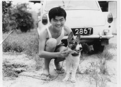
Photo 1: Different dogs from two different generations – Me and my son

As time went by, I kept more than one dog. At any one time I could have about 5 different dogs in the house. These pets were not necessarily pedigree but could be mongrels or cross-bred. The reason was simple. I started with an Alsatian bitch and a male Boxer. They had many off-springs because the dogs were not sterilized. Sometimes I took pity on friendly stray dogs and brought them into my house. There was one occasion when my aunty gave away her Dashhound. I never sent the dogs to any training school but personally undertook the task myself; sometimes my techniques worked, sometimes they flopped.

After I got married, my wife would not have anymore of my “nonsense”. I guess she was right in her opinions because we lived in a flat then. My two boys always wanted a pet; maybe this was inherited from my genes. There must be a reason that my old dogs never bit the children even when they winded up their tails, rode them like a rodeo-horse or opened their jaws.


Photo 2: Playing dead, sleeping on the desk, having her shower and on sentry-duty (Clockwise direction)

10 years ago my aunty gave us two kittens born on the day that Hong Kong was returned to China. One survived on three legs after some nutty motorist decided to run her down. It cost me closed to $2K going to Mt Pleasant Hospital for surgery, amputation and skin-grafting procedures. There was also two months of worries and nursing-care.

Personally cats are a different proposition unlike dogs because I never had any affinity towards them until now. Our black cat exhibits “dog behavior” for some strange reasons. Even my neighbors recognize that this is the only Chinese fella who whistles to his cat to come home every evening. Once a Malay neighbor asked a surprising question; “You are Chinese how come you keep cats and not dogs?”


Related posts


1) Our Kampong Best Friends
2) Oldest Cat on the Blog

Wednesday, May 28, 2008

Do you know where is this place?

My blogo-friend, YG has put up a couple of interesting photos in his blog. They show what looks like a farm house complete with chickens grazing outside.


It's hard to believe that such a farm house can be found right here in Singapore. Do you know where he took these photos? I give you 3 guesses:

1) Lim Chu Kang
2) Lorong Buangkok
3) Bukit Timah

To find out the answer; go to YG4.

Sunday, May 25, 2008

Ulu Pandan Heritage Trail (10) – The Lost Railway Line: Part 2 (by Peter Chan)

Photo 1: View from Clementi Block 307 showing the Jurong Line as it crossed the Sungei Ulu Pandan

After the railway crossed the Sungei Ulu Pandan, it swerved to the right (the tracks are still there in front of Clementi blocks 301 and 305) and ran parallel to the river until somewhere behind the Clementi Fire Station and the Buddhist Temple. Then it turned to the left, cut across Commonwealth Avenue West and ran behind ITE Clementi and Faber Terrace until it reached the AYE where it then followed the road westward to Jurong. Next time you travel along the AYE towards the city, look to the left just after the Teban Flyover and you will see some remnants of the railway track. Likewise, if you are traveling along AYE towards Jurong, after you passed Penjuru Road, look to the left and you will also see some remnants of this track.

At Jurong, the Jurong Line terminated at the doors of different industrial activities. Some railway friends of mine spent many hours using old 1960s and recent photos, and the 1985 Street Directory to piece together the many prominent landmarks along the Jurong Line. My appreciation goes to Dominic Thomas and Stanley Tan.

In total there are 3 sub-branch lines ending at.

1) Fishery Port Road
2) Jalan Tepong
3) Shipyard Road


Photo 2: Various parts of the Jurong Industrial Estate were served by the Jurong Line


Photo 3: The “ends” of the Jurong Line

Photo 4a: Jurong Station Signage in recent years


Photo 4b: The same Jurong site some decades earlier. The time-keeper’s hut is visible


Photo 4c: A 1993 map showing the location of the SBS depot at Jurong Port Road


Industrial users of the Jurong Line included Pan Malaysian Cement Works Ltd, Asia Cement (Malaysia) Ltd, Sugar Industries of Singapore Ltd, and an oil storage company.

The Jurong Line slowed down its freight activities in the mid-1970s but this finally ended in the early 1990s, by which time only the Jurong Port Road section towards Jurong Port was busy. By the mid-90s it was proving difficult to spot its alignment. Not many of the old Jurong Line and its prominent landmark features were visible to the casual observer, unlike the railway bridge across the S. Ulu Pandan or the Teban Garden Tunnel. Railway tracks were either removed because of new construction projects or covered by thick vegetation. Even the wooden railway sleepers rotted over time.

Here’s a question. We know that Malayan Railway Berhad (or its successor KTM) operated the Jurong Line. Who owns the land on which the railway track was built?


Final note from authors:

This concludes our series of articles on the Ulu Pandan Heritage Trail. We hope you have learnt something from them. Perchance some young reader has developed an interest in Singapore’s history, we encourage you to take this up as a school project. Go and investigate some of the places that we have told you about. Take some photos to show to future generations. We fear that before long, even these last vestiges of Singapore’s lost railway line will be sacrificed in the name of progress in fast changing Singapore.

Friday, May 23, 2008

Ulu Pandan Heritage Trail (9) – The Lost Railway Line: Part 1 (by Peter Chan)

In the previous article, Chun See told you about the disused railway line across the Sungei Ulu Pandan. This line was actually part of what was called the Bukit Timah Siding. As the name implies, it was actually an extension of the main Malayan Railway Line which went from Tanjong Pagar to Peninsula Malaya. It was connected to the main railway line near the Bukit Timah Station. After crossing S. Ulu Pandan, it continued all the way to Jurong. Hence it was called the Jurong Line.

According to the 1960 Malayan Railway Berhad Annual Report, the Jurong Line was built by and the project funding came from the company itself and not the Singapore Government. The only reason for the existence of the Jurong Line was purely economics. When Singapore was a part of Malaysia, it was envisaged that Singapore was to be the heavy industrial hub of Malaysia through the Jurong Industrial Estate. At the same time, a small number of Malaysian companies producing essential commodities like sugar were to be relocated to Singapore. In order to obtain the raw materials for the Jurong heavy industries; the steel was required by the Jurong Shipyard from Prai, and not to clog up the Woodlands and Bukit Timah roads a railway track that ran-off the main Malayan Railway line was built. Historically much of Peninsular Malaya’s (and the future Malaysia) natural commodities such as rubber and tin were routed through the port of Singapore at Tanjong Pagar. So creating an extension from the main railway line was not all that difficult. Is this a surprise? Not really because when I worked for a large US MNC in the mid-1980s, I found that many of Malaysia's IT requirements from Europe and the US were re-exported from Singapore.

Today, I will describe for you the section near Clementi. Next time, I will describe the Western section.


Picture 1: Bukit Timah Siding

I used to travel the stretch of Clementi Road and Bukit Timah Road very often. Around 1960 or 1961, I saw huge excavators digging at the spot where Lorong Gaung used to be. The space next to Lorong Gaung finally became a deep valley which is now the tunnel under Clementi Road.


After Singapore separated from Malaysia, I found military trucks using a narrow dirt track (passable to only one vehicle at a time) running above the valley. The dirt track was Lorong Gaung which connected the Old Maju Camp with Clementi Road. Maju Camp was a People’s Defense Force Camp which trained volunteers for the army in the days before National Service was introduced in 1967. It was scary to see the 3-tonners getting stuck halfway up the muddy steep dirt-track and men pushing the vehicle forward. When the vehicle finally could get started, you could see the rising black exhaust smoke.


Picture 2: Map of Clementi Road area from 1981 street directory showing location of Lorong Gaung off Clementi Road. Notice that there was an Old Clementi Road at the lower part of the map. Notice also a Singapore Boys' Home and a Ngee Ann Technical College further up.
This is a recent photo of the railway bridge over Sunset Way.


Picture 3: PDF soldiers coming out of Maju Camp to main Clementi Road. This place is directly opposite the future Corona Florist nursery.


Today there are some small evidences that the valley and dirt track did exist.

Picture 4: Old entrance to Maju Camp marked by road block pillars.

At the same time, I saw the building of the railway bridge across the S. Ulu Pandan. There was a small dirt track to the left of and before the Sunset Way railway bridge. This dirt track lead to a British Army Camp called Colombo Camp. I used to see British military tanks doing their maneuvers in the area across the S. Ulu Pandan.

Photo 5: Down in the valley, the old railway track is still visible to the eye

How come I knew so much? Well we had our family outings to Clementi Park when it was first offered for sale by City Developments Ltd in the early 1960s. My 98 year old grand-uncle, who still lives at Sunset Drive, briefed the rest of the family members about his new bungalow. As for me, I was not interested in those adult conversations and was more tempted to watch the railway bridge under construction.

Coincidentally the S. Ulu Pandan railway bridge has a uncanny resemblance to a bridge in the movie, “Bridge On The River Kwai”, especially during sunset and when there are no HDB estates around it. Close your eyes, you can hear “Colonel Bogey” whistled by the POWs.
Recommended Read: Icemoon's follow-up to this article; Old tracks, New Trail: The bridge over the River U. Pandan.

Monday, May 19, 2008

Ulu Pandan Heritage Trail (8) – The bridge that I ‘blew up’ twice (by Lam Chun See)

If you were to travel along Clementi Road in the direction of Bukit Timah, you will cross the Sungei Ulu Pandan near the junction with Ulu Pandan Road. If you looked to the left, towards Clementi Avenue 6, you will see a pedestrian bridge with white canopy. And if you were observant enough, you will notice another bridge a hundred metres or so behind it. This is a black colour iron rail bridge. Have you ever wondered why they built such a strange bridge there? Do you know the history behind this bridge?

Ulu Pandan Railway Bridge - May2008 (22)

Picture 1 - Sungei Ulu Pandan viewed from Clementi Road (in direction of Clementi Ave 6)

Well, I too do not know the history of this bridge. So I will have to leave it to Peter to tell you more about it in the next article. All I know is that a railway track runs across this bridge. (I use the present tense because the railway track is still there as you can see from the photos below) This railway starts at the KTM (Malayan Railway) track somewhere between Holland Road and Bukit Timah Road. After it crosses this railway bridge, it swings to the right running parallel to Sungei Ulu Pandan towards Jurong East direction and ends at a few points in the western end of Singapore; the furthest being at Shipyard Road, near Pulau Sumulun.

Ulu Pandan Railway Bridge - May2008 (15)

Picture No. 2 – View of the railway track crossing Railway Bridge from Clementi Block 305

Ulu Pandan Railway Bridge - 1993 map

Picture No. 3 – Map of the Ulu Pandan Railway Bridge and vicinity from a 1993 street directory


But I do have some close and personal knowledge of this railway bridge because during my active NS days, I took part in 2 exercises to demolish this bridge. The first was when I was attending the Junior Officers Engineers Course at Gillman Camp. The second was when I was a platoon commander in Mandai Camp. I have blogged about the second exercise before, and so today, I will just talk about that first encounter with this bridge.


During my JOE course, the very first exercise; if my memory serves me, was a demolition raid called Exercise Musang (or Mongoose, I am not too sure). As trainees, we hated this type of exercise for two reasons. (1) Such demolition raids were always conducted in the dead of the night, which meant that by the time we returned to camp and cleared the stores and so on, we won’t have many hours left to sleep. (2) Such raids typically ended with a fire fight which meant that there will be casualties to evacuate during the withdrawal phase.

For this particular exercise, our RV (rendezvous) point was at Dover Road. From there we moved on foot to the car park at Sunset Avenue (now occupied by a small shopping mall called Sunset Arcade), formed up and proceeded to set up the charges according to plan. After the bridge and surrounding tracks were successfully demolished, and the enemies killed in the ensuing firefight; the controller called for a halt. This was so that we could dismantle all the dummy charges and detonating cords etc. and pack them onto the 3-tonner. After that the exercise resumed and we had to withdraw with our casualties back to the RV at Dover Road. We took turns to carry the casualties using the fireman lift method. In those days (1977), traffic along Clementi Road was very light after midnight and so we did not cause any traffic jam.


Ulu Pandan Railway Bridge - from Picas 1991 (1)

Picture No. 4 – A 1991 photo of the Ulu Pandan Railway Bridge from the National Archives Collection

Ulu Pandan Railway Bridge - May2008 (12)

Picture No. 5 – A May 2008 photo of the Ulu Pandan Railway Bridge taken from a similar angle

Ulu Pandan Railway Bridge - May2008 (7)

Picture No. 6 – This recent photo shows remnants of the railway track that runs over the now disused bridge.

Besides this exercise we had 2 other demolition raids in our JOE course. One was to blow up the bridge joining Shipyard Road to Pulau Sumulun. This one was quite tricky because we had to lower the men by toggle rope to attach the ‘explosives’ to the pillars.


The third exercise was in Sungei Gedong area. A funny thing happened during the withdrawal stage. A very friendly stray dog ran along with us all the way to the RV point. When we finally departed by 3-tonner, the poor dog was unable to follow us and he looked so sad.

Today I often travel along Clementi Road. Each time I pass Sungei Ulu Pandan and see the bridge in the distance, my mind goes back to that night 31 years ago. When I see the busy traffic along this stretch of Clementi Road, I just cannot picture myself and my buddies evacuating casualties along it.

My …….. how much Singapore has changed in one generation.


P.S. - To get a clearer view of the pictures, just click on it to go to my Flickr account.